After about two hours at Wal-Mart (which included lunch at Subway – there was even a Subway in the Wal-Mart!), we arrived at a massive bridge over the Colorado River. This turned out to be the Glen Canyon Bridge, just below the Glen Canyon Dam. There was a visitors center on the opposite side, so we crossed the bridge and stopped in. There happened to be a dam tour with space available coming up soon, so we signed up for that and spent a few minutes looking around the visitors center. We learned that Glen Canyon Dam is 710 feet high, making it the second-highest dam in the U.S. The only one higher is Hoover Dam, a little ways down the Colorado River, which is 16 feet taller.
Here’s the view of the dam from the visitors center:
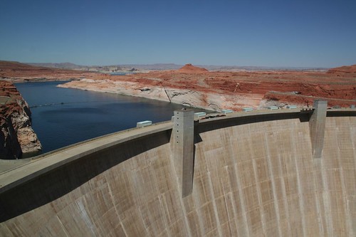
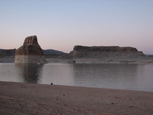
That’s Lake Powell above the dam, the second-largest man-made lake in the U.S. based on volume, just behind Lake Mead, the lake above Hoover Dam. However, Lake Mead is like a big bowl whereas Lake Powell snakes around a lot, so Lake Powell has about 1900 miles of shore line, vs. Lake Mead’s 550, making Lake Powell a very popular recreation spot.
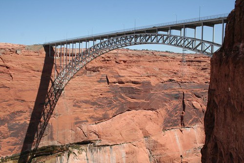
And here’s the view looking back at the bridge. Glen Canyon Bridge is the second-highest steel bridge in the U.S., 700 feet above the Colorado River:
At 1:30, we started the tour. As we began the tour, our highly exuberant tour guide explained the purpose of the dam. The Colorado supplies much of the water for the generally arid American Southwest and some of Mexico as well. Because water is such a scarce resource in the Southwest, an agreement among seven states was reached in the 1920s to allocate the river’s water among those states. Mexico was in revolution at the time, but a later agreement with Mexico carved out their share. The Hoover Dam, Glen Canyon Dam, and various smaller dams along the Colorado ensure that regardless of the year’s snowpack and consequent flow of the river, each state gets its agreed-upon allocation.
We took an elevator way down to the dam and got to walk out on top of the dam – after a firm warning from our tour guide that the dam is a pretty high-security federal area so we shouldn’t say or do anything that we wouldn’t on, say, an airplane.
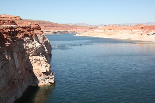
The top of the dam afforded a nice view of Lake Powell:
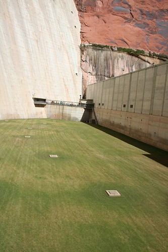
Construction of the dam was authorized in 1956, and for three years, construction crews prepared the area, building the town of Page, among other things. In 1960, the first bucket of concrete was dumped, and in 1963, construction of the dam was completed. Apparently, Ladybird Johnson was on hand at the 1966 dedication and suggested that an area of bare dirt below the dam would be better off covered in flowers. The folks running the dam thought that sounded like a lot of work, but they planted grass instead:
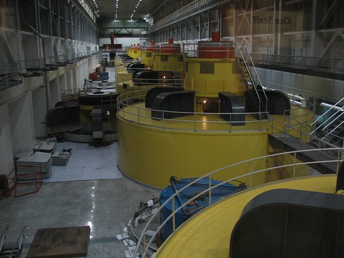
We descended further into the bowels of the dam, walked past the grassy patch, and into the viewing area for the hydroelectric power plant. The main purpose of the dam is metering water out to the states, but as long as they have the water dammed up in Lake Powell, the Bureau of Reclamation decided that they might as well make some money by generating and selling power. So they built the power plant, with eight 155,500-horsepower turbines. Since the dam opened, it’s generated over $2 billion in power, paying for the Glen Canyon dam as well as funding other dam projects that don’t have power plants to allow self funding.
Here’s a shot of the turbines. The electromagnet is hard too see, way on the left side of the back wall.
In the visitors center, we saw the weather forecast for Bryce Canyon – 13 degrees tonight! Brr! So we quickly changed our plans. The Glen Canyon area was nice and warm, so we decided to stay there to camp. Now we had a few hours free, so we went to the trailhead for Horseshoe Bend, recommended as a pretty hike by our tour guide. The route to the trailhead took us past Wal-Mart again. Since we’d finished our cream eggs and had collected a lot of pennies during our travels, we decided to clean out our change dish and acquire four more Cadbury cream eggs.
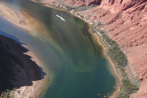
Horseshoe Bend turned out to be a really pretty curve in the river below the dam:
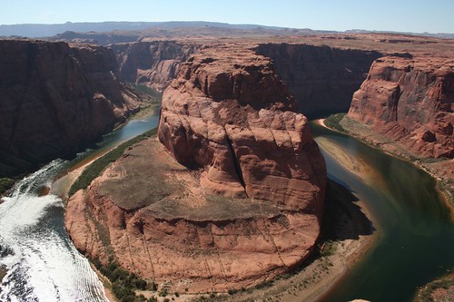
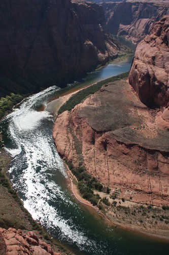
The area is very popular for recreation, and we saw a couple of boats cruising down the river:
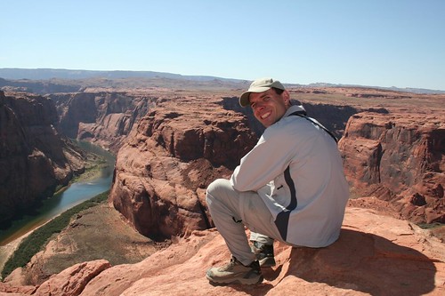
Here’s Brian enjoying the view:
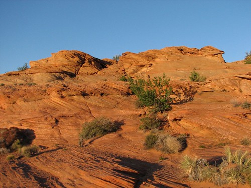
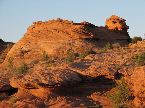
After the hike, we spent a few hours catching up on email and talking on the phone, thinking that Page, Arizona, might be our last contact with civilization for a while. Then late in the afternoon, we took a short walk to a viewpoint of the dam. The walk took us past some petrified dunes, which were really pretty in the late-day light.
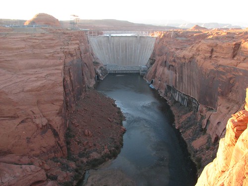
The view of the dam was impressive:
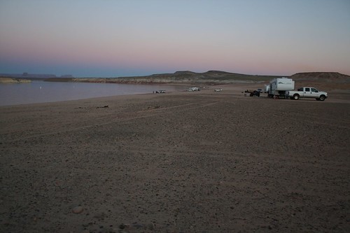
In the visitors center, we had heard about a primitive campground called Lone Rock right on the lake, so we headed there to set up our tent. We got there right around sunset and found that the “campground” was actually a big swath of beach, and people just drove their vehicles right out on the sand! There were a lot of motorhomes and trailers out there that seemed less beach-worthy than Caroline, so without fear, we set out on one of the paths through the sand. The path was mostly packed down, but in a few places we were afraid we might get stuck in the sand. Driving on soft sand is surprisingly similar to driving on snow.
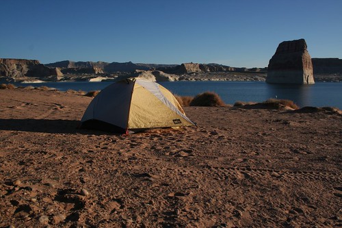
Without serious incident, though, we made it to the area where people seemed to be setting up their campsites. We found an open spot and set up our tent. By now it was just after sunset, but the view from our site was still quite pretty:
We made dinner, drank our bottle of Wal-Mart cabernet (surprisingly decent), and went to bed.
Around 3:00 in the morning, Brian had to go to the bathroom. Camping on the beach was great, except for one small problem – the bathrooms were maybe a half mile away. For some reason, Brian decided not to pee on the beach, and walked the half mile. Finding the bathroom was easy – it was well-lit. Finding his way back? Much harder – the tent was definitely not well-lit. Brian walked for a while, passed a closed outhouse that he thought was near the tent, then kept walking. It didn’t feel like he was in the right place, so he went back to the outhouse and realized that it wasn’t at all near the tent – the one near the tent had a number seven on it, and this was number one. In fact, he’d walked at a right angle to the direction he should have been walking!
With this information, he thought he knew the direction of the tent and set off in that direction. Eventually, he reached a deep ditch, which he didn’t remember at all from earlier in the day. Nevertheless, he was convinced he was going in the right direction, so he tried crossing the ditch. It was really deep, though, so although he could hike in on one side, he couldn’t very easily get out on the other side. So he walked inside the ditch for a ways, looking for a way out, and didn’t find one. Now he felt like he was definitely going in the wrong direction, so he turned around and exited the ditch where he had entered.
Still convinced he was headed the right direction, he followed along the edge of the ditch. After what felt like a really long time, he got concerned that maybe the ditch wouldn’t end anytime soon, and decided he needed a Plan B. Fortunately, throughout his wanderings, he’d kept the well-lit bathroom in view, and since he had to admit now that he was completely lost, he decided to walk a long way back to the bathroom and start over.
This time, he set off in a slightly different direction and didn’t hit any unexpected outhouses or ditches. After a long walk, he saw a light and walked toward it, thinking it might be Sarah. Sure enough, Sarah had gotten worried when Brian didn’t come back, so she walked outside the tent with her headlamp. Brian followed the light the rest of the way, and they went back to bed. Now it was about 4:00. Brian insists that this time, he was going the right direction and would have made it back to the tent on his own, but he definitely didn’t complain about the headlamp beacon. If this second try hadn’t been successful, he would have had to go to Plan C, which would have been to spend the night in the bathroom – he didn’t have enough clothing on to stay outside until daylight.
After sleeping a bit late the following morning, we got up to make breakfast, taking one last picture of our beautiful campsite before we left:
No comments:
Post a Comment