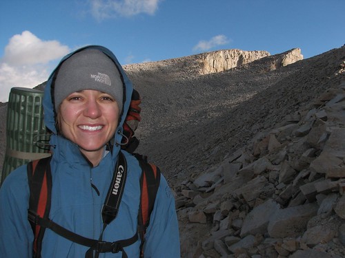
The next topic that we wanted to cover for the benefit of future JMT hikers is bear safety. If you’re a regular reader of our blog, you may recall that we had a run-in with a bear in the San Gorgonio Wilderness back in May, and then of course, in Yosemite, a bear ripped our car open. So we have some experience dealing with California bears, and hope that others can learn from our mishaps.
When we arrived in Yosemite, we knew that bears there are notorious for bad behavior, and we were repeatedly warned about how to protect ourselves and our property. The park entrance station, the park newspaper, and signs in the campgrounds all told us that when we parked overnight, we needed to remove everything from our car that had any smell – all food and toiletries had to go.
When we got our wilderness permit, the ranger at the wilderness station reiterated the warning, saying that we needed to make sure that we transferred anything with a taste into the bear-proof lockers in the trailhead parking lots. She used the same examples – food, toothpaste, lotions, deodorant, baby wipes, etc. At the desk in the wilderness office, they showed a photo of a car that a bear had broken into, with its door frame bent down. We asked about our cooler, which was empty, and the ranger said we should be OK to leave it in the car if we cleaned it out well and made sure it wasn’t visible. She explained that bears don’t just smell for food – they also look into cars, and if they see something like a cooler that looks like a food source, they may break in even if they can’t smell anything.
We spent much of the rest of the day clearing out our car lest it suffer the fate of the car in the photo. We consolidated all of our smelly items into a couple of bins. We noticed that some of our blankets smelled from being packed in a bin near toiletries, so we laundered those. We washed out our empty cooler with soap and water. When we felt like we’d done everything we could to make our car unattractive to a bear, we parked it in the overnight parking lot. After opening and closing several lockers, we found an empty locker and put our smelly stuff inside. We were uncomfortable leaving some of our stuff, including dishes and cookware that would be expensive to replace, in a locker that was bear-proof but hardly people-proof, but we did it anyway. We also noticed that visitors had locked several of the lockers, despite warnings that the lockers were to be shared and locks would be cut off.
After transferring our food and toiletries to the locker, we still had duffel bags of clothing and other gear in the car – after all, we’ve been living out of our car. None of this stuff seemed like it would be interesting to a bear, but to be extra-safe, we put a bed sheet over everything, to reduce the appearance of clutter.
On the way to the trailhead the next morning, we stopped at our car to drop off a few things that we wouldn’t be carrying them with us on our hike. When we got to our car, a park vehicle was already there, and two park officials were writing up an incident report. Despite all our hard work the previous day, our car had been attacked by a bear! The door frame was bent down at a 45-degree angle, and the window was sitting in shards on the ground. Interestingly, the interior of the car was hardly disrupted – the sheet that we’d used to cover our bags was tossed aside, and a duffel bag was moved to the front seat from the back of the car. The cooler was moved, too. But the bear didn’t open any bags or make any other mess. It looked like a very quick job – break in, sniff around for food for a minute or two, and leave to try his luck on another car.
The male official did most of the talking, and he said we were lucky that he wasn’t a ranger. He pointed at the stuff in the back of our car – the duffel bags, bins, and cooler that were now plainly visible, given that the bear had removed the bed sheet that had been covering them – and said that if he was a ranger, he would have impounded our car and we would have been fined thousands of dollars. We didn’t understand what we had done wrong, given that we’d followed all the regulations and then some, but we were in such a state of shock that we were actually a bit grateful – at least the official wasn’t going to fine us! The officials told us that we should take our car to the Yosemite Valley garage, where they could tape or board up our door for us, and then we could head out on our trip. They didn’t ask us any questions about what we had done to bear-proof our car; they just completed writing up their incident report and gave us a report number and a phone number that we could call.
We weren’t comfortable with leaving our car in the parking lot with just tape over the door, but we headed over to the garage anyway. The staff turned out to be extremely friendly and helped us find a towing company and a body shop that could fix up our door for us while we hiked. After that, we settled in to wait for the tow truck to arrive.
The incident report card that the official had provided indicated that we should call the park office to complete our report. Since he hadn’t asked us any questions about the bear-proofing we had done, we felt it was our responsibility to call the office to let them know the details of what had happened. They would probably want to know exactly what was in our car and what state of organization it was in, so that they could understand the behavioral patterns of this particular bear and reduce the likelihood of negative bear/people interactions in the future.
So while we were waiting for the tow truck to arrive, Brian called the office. The person who answered the phone was the same park official who had taken the report. Brian started a conversation, and after a few minutes, it became clear that the official thought the report was complete – there was nothing more that would be useful for the park service to know. The official said once, “Well, at least you’ve learned a lesson.” When he repeated that comment a second time, Brian asked, “What lesson were we supposed to learn?” The official said that we couldn’t leave anything at all in our car. When Brian pointed out that the park guidelines were not consistent with this, explicitly stating that park visitors should remove items with a smell from their cars, the official said, “Those people who write the guidelines, they don’t know the bears like I do.”
Later in the conversation, Brian asked what would be done about this particular bear. After all, it was pretty clearly a problem bear, breaking into a car without provocation. Surely, the park service would do something to deter this bear from attacking cars in the future. The official said, “The bear’s not the problem. You’re the problem.” He said that the bears were in Yosemite first, before people, and we were encroaching on their territory. The bear was just being a bear, and after all, we’d left all that stuff in the car to entice it.
So let’s see… Park officials blame all negative bear/people encounters on the people – the bears are immune from any responsibility. Park officials display no interest in asking questions to gather information about the details of a particular bear/people encounter that might be useful to prevent future such encounters – after all, the people are always at fault, so there’s nothing more to learn. The park’s guidelines – published in the park newspaper, at the entrance stations, and at campgrounds, and espoused by rangers – aren’t written by people who know the bears, and are woefully inadequate to protect people and their property from the bears.
After our car was on its way to the body shop, we headed back to the wilderness office to talk to a ranger, to try to square the park official’s admonition that we could have nothing in our car with the wilderness office’s guidance that we just remove items with smell and taste. The ranger who had issued our permit the previous day wasn’t there, so we talked to another ranger. He admitted that yes, our car would have been safer if it had been completely empty, but unfortunately, the park doesn’t have enough bear lockers in the parking lots to support such a policy, and the lockers aren’t secure from theft, so recommending that cars be completely emptied would just trade a bear problem for a theft problem. Besides, he said, even completely emptying a car might not be enough. A bear may break into a Honda CR-V once and get some tasty food out of it and decide that CR-Vs are yummy food sources, so it may break into a few more CR-Vs in the hope of getting more food. Yes, bears are apparently that smart – they can recognize the make and model of a car! Or maybe a bear learns that CR-Vs are relatively easy to break into, and that encourages future CR-V break-ins. Or a bear may see color as a sign – the bear breaks into a green vehicle and gets some food, and then continues to break into other green vehicles, without any provocation. So parking an empty car overnight is better than parking a car with a bunch of duffel bags in it like we did, and that’s definitely better than leaving food and toiletries in your car, but the bears are so bold and so smart that even emptying your car isn’t fool-proof.
And of course, this wasn’t our first negative bear encounter in California. The bear that stalked us near L.A., after all, was descended from Yosemite problem bears. In the 1970s, back in the day when the park service actually fed garbage to the bears to bring them into the frontcountry so that visitors could see them, problem bears were relocated. Now, though, relocation has fallen out of favor as a management practice – it just spreads out the problem, and oftentimes, the relocated bear will find its way back anyway. Nowadays, the only way of dealing with a problem bear is to kill it. As the National Forest rangers in California told us, they couldn’t do anything at all about the bear that had stalked us – if they reported the incident to Fish and Wildlife, that department would kill the bear. And the rangers didn’t want that. After all, the bear had just stalked us – it hadn’t even bluff-charged us to try to get us to drop our packs! It could have been worse!
Based on these incidents, it seems that California park management has adopted a consistent policy of ignoring, and therefore enabling, bad bear behavior. If your kid stalks another kid, you punish your kid to deter such behavior in the future. If your kid rips apart your car, causing over $1000 worth of damage, you definitely punish your kid. But if a bear does the same thing, park management turns the other way, either admitting that the bear has done wrong but claiming their hands are tied or, in the case of the park official who took our incident report, projecting blame onto us.
Contrast this with the policies of park management outside California. Brian’s sister, once a park ranger at Rocky Mountain National Park in Colorado, was appalled at the story of the bear near L.A. – if a bear behaved that way in Rocky, she said, it would be shot, not punitively, but rather to protect the rest of the bear population. We’ve seen plenty of bears in other national parks – Rainier, Yellowstone, Glacier – and they all keep their distance. When we’ve met bears in the backcountry in Rainier, for instance, they’ve most commonly run away from us. The few that didn’t simply ignored us and went about their business while we went about ours. No bear outside California has ever displayed the remotest interest in us, much less stalked us. And in all of those parks, keeping your food and toiletries in a hard-sided vehicle is totally sufficient to protect those items – and your vehicle – from bears.
In California, on the other hand, a bear attacks a car, and regardless of what the owner of the car has done to follow park guidelines, it’s the human’s fault. The bear is free to come back the next night and attack a different car, becoming increasingly bold, knowing that the risk that it’s taking is low. The reward may also be low – maybe only one in ten cars has some tasty morsel inside, given park visitors’ efforts to bear-proof their cars – but given zero consequences, that reward is enough for the bear to keep trying, doing hundreds or thousands of dollars worth of damage with each attack. Worse, what if that bear is a female and gives birth to baby bears? How do those babies learn to forage for food? From their mother, of course, who not only teaches them which berries are good to eat, but which types of cars are good to break into, and how to break into them.
As vehicle break-ins become more socialized into the bear population, the overnight parking lots, jokingly known as “bear buffets,” become a reliable food source. Bears don’t have predators in the area, so what limits their population? It’s the food supply. Increase the food supply by augmenting the berry bushes with overnight parking lots, and the park can support more bears. As the bear population grows, given its increased food supply, it becomes dependent on that food supply, and if the supply becomes more difficult to access – perhaps due to stricter park regulations that result in less food left in cars – the bears become increasingly aggressive in their fight for survival.
Ironically, the park official that took our incident report, who refused to hear any evidence that the bear that had attacked our car might be a problem, said his job was to “protect the bears” when in fact, he was saving one bear but destroying the population. Killing a single badly behaved bear is a widely accepted practice on public lands outside California – rather than being the cruel practice that some would make it out to be, it’s the only known way to save the population from developing habits that endanger the entire group. Bad behaviors may be so socialized into the Yosemite bear population at this point, though, that bear management practices used outside California would be ineffective.
The lesson for California’s public-lands management is clear: Admit the problem, and start to work on correcting it, rather than continuing to protect one bear at the expense of the population.
What’s the lesson for JMT hikers, or Yosemite backpackers in general? The best thing to do is simply not to bring your car into the park. There’s a surprisingly good public transportation system around Yosemite, so parking outside the park and taking buses into Yosemite is actually a viable option. If you’re thru-hiking the JMT, you need to take a shuttle at the beginning or end of your hike anyway to get back to your vehicle, so leaving your car in Mammoth or Bishop rather than inside the park isn’t really an inconvenience.
If you really want to take your car into the park and you’re going to park it in a “bear buffet,” then make sure that there’s nothing at all inside the car, but know that even that might not be enough.
All in all, after our experience, we wouldn’t go back to Yosemite just for a weekend backpacking trip – it’s just not worth it, given the risk and/or inconvenience. For a longer trip, like the JMT, we would park outside the park. The trip was fantastic enough that even after spending $1000 to replace our door, it was worth it, but if we were to do it again, we’d avoid that expense by parking outside the park and not serving up our car for dinner.
Tuesday, September 30, 2008
Monday, September 29, 2008
JMT - Planning Food
Next we’ll discuss planning and packing food for the John Muir Trail. Attitudes regarding food on the trail were about as diverse as gear styles. Some people were way short on food due to what appeared to be inappropriate planning. For example, one couple ate only one meal a day for several days while doing 20-mile days, and Doug, despite having underpacked food on two previous JMT thru-hikes, still failed to pack enough snacks for mid-day calories. Then there were people like Isaac who planned on eating 2400 calories a day, knowing full well that he’d lose about 20 pounds over the course of the trip. Packing insufficient food, whether intentionally or unintentionally, seemed quite common. Also, some people chose not to carry a stove, and others carried a stove.
In addition to style, there are a number of other constraints that can make planning a challenge. You have to think about variety of taste and texture, calorie distribution (i.e. balancing carbs, fats, and proteins), size of food and calorie density (all this food needs to fit in the bear canister you’ll be carrying), cooking time (to minimize fuel usage), durability (some crackers will just turn to dust after being in a pack for a while), perishableness, balance of food groups, etc.
Calculating Calories
We’ve done a lot of backpacking and have plenty of experience packing for two-to-three-day trips. However, we’ve never actually calculated how many calories we carry, so determining a target calorie count was a bit of a guesstimate. If you read several different discussions of backpacking calorie requirements in books or magazines, you will undoubtedly get several very different calculation techniques and recommendations. One thing to keep in mind is that even though you may need a certain number of calories to replace the calories you’re burning, it may actually be a physical challenge to consume all those calories, even if the food is available.
We ultimately decided on 3000 calories per day for Sarah and 4000 calories per day for Brian. In hindsight, we definitely could have survived on fewer calories and lightened our loads. On the other hand, Sarah lost weight, so maybe she should have eaten more. All in all, we came pretty close to packing an optimal quantity of food.
We took a very analytical approach to our food planning. Between the two of us, we needed 7000 calories a day. For 17 days, that would be 119,000 calories. Then we broke those down by meals. For breakfast, we planned on eating an oatmeal concoction daily. We chose a variety of dinner entrees and for planning, averaged the number of calories in those dinners. Then we needed to get the rest of our 119,000 calories from lunch and snacks. Here’s the math:
Total calories – 7000 calories per day x 17 days = 119,000 calories
Breakfast calories – 1100 calories per day x 17 days = 18,700 calories
Dinner calories – 1000 calories per day x 17 days = 17,000 calories
Snack/lunch calories – 5000 calories per day x 17 days = 85,000 calories
(Yes, there is a bit of rounding here.)
Furthermore, we figured we could eat large meals at the cafés at Tuolomne Meadows and Reds Meadow, so on those two resupply days, we planned to get our 5000 snack/lunch calories at the cafés. So instead of packing 85,000 snack/lunch calories, we packed 75,000.
Once we’d determined how many snack/lunch calories to pack, we made a big table listing all of the different snack/lunch foods we could think of packing – granola, trail mix, M&Ms, fig bars, Clif and Luna bars, etc. For each item, we wrote down the number of calories per serving, the number of servings we’d pack, and then the total calories represented by each food item. For instance, we brought some Gatorade powder, which is 200 calories a serving. We brought 18 servings, for a total of 3600 calories. All right – only 71,400 snack/lunch calories to go!
We needed to calculate the calories in each resupply, too, so the table also had columns for each of the resupplies. We brought two servings of Gatorade with us at the beginning of the trip and packed three servings into the Tuolomne Meadows resupply, five into the Reds Meadow resupply, and eight into the Muir Trail Ranch resupply. Whether you use a table or some other organizational system, definitely make sure you have a system to make sure the right items are getting into the right resupplies. 119,000 calories is a lot of food and it’s easy to miscalculate or mispack items without a good tracking system in place.
Also, it may seem obvious, but keep in mind that packing for a hike like the JMT is not the same as packing for an overnight trip. An overnight trip is really a day and a half trip. If you are like us, you get home on the second night and have a huge dinner, so during the trip, we’ve actually run a calorie deficit, to be replenished at home. A calorie deficit is fine on a short trip, but if you continue with such a deficit, in several days you’ll likely be hungry, lacking energy, and spending your time dreaming of food instead of enjoying the scenery.
Shopping and Other Preparation Tips
Backpacking dinners, such as Mountain House or Backpackers’ Pantry, are easy to find at most any sporting goods store. REI has a particularly large selection of these sorts of dinners. If you plan ahead and watch their sales, you can sometimes get a deal.
Any store that sells bulk foods is a great place to get snacks or buy ingredients to make your own meals. Bulk foods are often cheaper than packaged alternatives, and with bulk foods, you can buy just the amount you actually need. If you are in the Northwest and near a WinCo Foods store, take advantage of their great bulk selection. Sometimes your regular grocery store (places like Safeway, Kroger, etc.) will have a bulk foods section, though in our experience, these places have a fairly limited selection. Natural food stores are also a good place to try. Online, Harmony House Foods has a great selection of natural dehydrated foods at a reasonable price (especially their backpacker sampler).
Packing your own meals instead of buying dehydrated meals can be quite economical and gives you more control over what you are eating. We find that these meals often feel more like “real” meals than dehydrated meals do, and we like that our own meals don’t have as many preservatives and other additives. We got most of our recipes from two cookbooks put out by The Mountaineers – Backcountry Cooking and More Backcountry Cooking. (Incidentally, these are great resources for general camping as well, though if we aren’t backpacking, we’ll often substitute fresh food wherever possible.) One thing to keep in mind, especially when packing your own meals, is that it’s always good to try the meals before you go. It stinks to sit down at the end of a long day of hiking, ravenous, only to find that dinner is an unappealing pot of sludge.
Definitely take the time to remove extra packaging and put things in Ziplocs instead. The packaging for store-bought backpacking dinners is especially inefficient. While cooking right in the packet is convenient and avoids dirty dishes, heavy reliance on these types of meals will almost certainly mean you’ll need to repackage them to get everything to fit in your bear canister. Real Ziploc bags are more durable and have better zippers than generic bags – save yourself the hassle of cleaning messes out of your pack and spend the extra money on Ziplocs. This is especially true in bear country, where you really don’t want your pack smelling like dinner. But remember that Ziplocs are not odor-proof. We packed several meals with curry in them and found that anything that was stored nearby – from M&Ms to fig bars – took on a slight curry flavor.
We think variety is important for a trip this long. There are definitely people who can pack the most efficient calories regardless of taste and force themselves to eat it. However, if you’re like most people and you get completely sick of eating too much of one thing – ramen noodles/trail mix/<insert overpacked food here> – then you probably won’t end up eating it. Then instead of getting the calories you need, you just have dead weight in your pack of undesirable food that you have to pack out. Variety is also key in deciding whether to carry a stove or not. If you have a lot of variety in your snacks, a stove may not be necessary. However, if you are eating a lot of the same thing, a hot meal at the end of the day can provide welcome relief from the monotony.
Remember to give yourself plenty of time to plan, shop for, and pack your meals. We spent multiple afternoons over the course of the summer getting everything ready.
Breakfast
Our standard breakfast is 1 1/2 cups of oatmeal, 1/2 cup powdered milk, and a couple tablespoons each of wheat germ, flaxseed meal, brown sugar, nuts, and dried fruit. For nuts, we used sliced almonds, chopped walnuts, or chopped pecans. For dried fruit, we used cranberries, raisins, or dates. Dried blueberries or apples are also yummy options. We usually use whole oats, but for this trip we used instant oats so that “cooking” was as simple as boiling two cups of water and adding our mix. This recipe made two servings.
Dinner
For dinner, we chose several meals that we like and rotated through them several times. The meals were barley and curry, red lentils and rice, red beans and rice, and pre-packaged dehydrated dinners.
For dehydrated dinners, we brought Jose’s Chicken Mole, Wild West Chili, Katmandu Curry, and Chana Masala, all from Backpackers Pantry. Since backpacking dinners tend to be low in calories (on average they contain roughly 350 calories per serving), we also packed soups and smoothies for nights when we were eating these meals to boost our dinner calorie count. As it turned out, the smoothies were really foul and we ended up tossing most of them – that was the one case where we didn’t heed our own advice of trying a meal before bringing it on the trip.
For beans and rice, we brought Zattarain’s brand mix. This mix has the disadvantage of being slower to cook than the dehydrated beans-and-rice dinners made especially for backpacking, but we think the texture and flavor is better.
We made the other meals – barley with curry and red lentils with rice – from recipes in the previously mentioned cookbooks. The curry in both of these recipes provided a nice contrast to our daily snacks, and curry is supposed to be an anti-inflammatory, which is good for a hike this long. The downside, as mentioned, is that curry flavor tends to ooze into all your other food. Curry M&Ms aren’t bad, but weren’t quite what we were expecting.
We also brought eight or so tea bags to go with breakfast or dinner. Given the weather we had, these were entirely dispensable. They probably would have been really nice if we’d had colder or wetter weather though.
Lunch and Snacks
On the trail, “lunch” for us is really a series of snacks, starting shortly after breakfast and ending about dinner time. We packed a large variety of items for snacks.
Of all the different aspects of a JMT trip that need planning – transportation, permits, gear, etc. – food may be the most difficult to get right. The consequences of getting it wrong may be the most severe as well, in terms of discomfort and unhappiness on the trail. There are lots of different valid approaches, but ours worked well for us, and we hope future hikers can use it or adapt it for their own needs.
In addition to style, there are a number of other constraints that can make planning a challenge. You have to think about variety of taste and texture, calorie distribution (i.e. balancing carbs, fats, and proteins), size of food and calorie density (all this food needs to fit in the bear canister you’ll be carrying), cooking time (to minimize fuel usage), durability (some crackers will just turn to dust after being in a pack for a while), perishableness, balance of food groups, etc.
Calculating Calories
We’ve done a lot of backpacking and have plenty of experience packing for two-to-three-day trips. However, we’ve never actually calculated how many calories we carry, so determining a target calorie count was a bit of a guesstimate. If you read several different discussions of backpacking calorie requirements in books or magazines, you will undoubtedly get several very different calculation techniques and recommendations. One thing to keep in mind is that even though you may need a certain number of calories to replace the calories you’re burning, it may actually be a physical challenge to consume all those calories, even if the food is available.
We ultimately decided on 3000 calories per day for Sarah and 4000 calories per day for Brian. In hindsight, we definitely could have survived on fewer calories and lightened our loads. On the other hand, Sarah lost weight, so maybe she should have eaten more. All in all, we came pretty close to packing an optimal quantity of food.
We took a very analytical approach to our food planning. Between the two of us, we needed 7000 calories a day. For 17 days, that would be 119,000 calories. Then we broke those down by meals. For breakfast, we planned on eating an oatmeal concoction daily. We chose a variety of dinner entrees and for planning, averaged the number of calories in those dinners. Then we needed to get the rest of our 119,000 calories from lunch and snacks. Here’s the math:
Total calories – 7000 calories per day x 17 days = 119,000 calories
Breakfast calories – 1100 calories per day x 17 days = 18,700 calories
Dinner calories – 1000 calories per day x 17 days = 17,000 calories
Snack/lunch calories – 5000 calories per day x 17 days = 85,000 calories
(Yes, there is a bit of rounding here.)
Furthermore, we figured we could eat large meals at the cafés at Tuolomne Meadows and Reds Meadow, so on those two resupply days, we planned to get our 5000 snack/lunch calories at the cafés. So instead of packing 85,000 snack/lunch calories, we packed 75,000.
Once we’d determined how many snack/lunch calories to pack, we made a big table listing all of the different snack/lunch foods we could think of packing – granola, trail mix, M&Ms, fig bars, Clif and Luna bars, etc. For each item, we wrote down the number of calories per serving, the number of servings we’d pack, and then the total calories represented by each food item. For instance, we brought some Gatorade powder, which is 200 calories a serving. We brought 18 servings, for a total of 3600 calories. All right – only 71,400 snack/lunch calories to go!
We needed to calculate the calories in each resupply, too, so the table also had columns for each of the resupplies. We brought two servings of Gatorade with us at the beginning of the trip and packed three servings into the Tuolomne Meadows resupply, five into the Reds Meadow resupply, and eight into the Muir Trail Ranch resupply. Whether you use a table or some other organizational system, definitely make sure you have a system to make sure the right items are getting into the right resupplies. 119,000 calories is a lot of food and it’s easy to miscalculate or mispack items without a good tracking system in place.
Also, it may seem obvious, but keep in mind that packing for a hike like the JMT is not the same as packing for an overnight trip. An overnight trip is really a day and a half trip. If you are like us, you get home on the second night and have a huge dinner, so during the trip, we’ve actually run a calorie deficit, to be replenished at home. A calorie deficit is fine on a short trip, but if you continue with such a deficit, in several days you’ll likely be hungry, lacking energy, and spending your time dreaming of food instead of enjoying the scenery.
Shopping and Other Preparation Tips
Backpacking dinners, such as Mountain House or Backpackers’ Pantry, are easy to find at most any sporting goods store. REI has a particularly large selection of these sorts of dinners. If you plan ahead and watch their sales, you can sometimes get a deal.
Any store that sells bulk foods is a great place to get snacks or buy ingredients to make your own meals. Bulk foods are often cheaper than packaged alternatives, and with bulk foods, you can buy just the amount you actually need. If you are in the Northwest and near a WinCo Foods store, take advantage of their great bulk selection. Sometimes your regular grocery store (places like Safeway, Kroger, etc.) will have a bulk foods section, though in our experience, these places have a fairly limited selection. Natural food stores are also a good place to try. Online, Harmony House Foods has a great selection of natural dehydrated foods at a reasonable price (especially their backpacker sampler).
Packing your own meals instead of buying dehydrated meals can be quite economical and gives you more control over what you are eating. We find that these meals often feel more like “real” meals than dehydrated meals do, and we like that our own meals don’t have as many preservatives and other additives. We got most of our recipes from two cookbooks put out by The Mountaineers – Backcountry Cooking and More Backcountry Cooking. (Incidentally, these are great resources for general camping as well, though if we aren’t backpacking, we’ll often substitute fresh food wherever possible.) One thing to keep in mind, especially when packing your own meals, is that it’s always good to try the meals before you go. It stinks to sit down at the end of a long day of hiking, ravenous, only to find that dinner is an unappealing pot of sludge.
Definitely take the time to remove extra packaging and put things in Ziplocs instead. The packaging for store-bought backpacking dinners is especially inefficient. While cooking right in the packet is convenient and avoids dirty dishes, heavy reliance on these types of meals will almost certainly mean you’ll need to repackage them to get everything to fit in your bear canister. Real Ziploc bags are more durable and have better zippers than generic bags – save yourself the hassle of cleaning messes out of your pack and spend the extra money on Ziplocs. This is especially true in bear country, where you really don’t want your pack smelling like dinner. But remember that Ziplocs are not odor-proof. We packed several meals with curry in them and found that anything that was stored nearby – from M&Ms to fig bars – took on a slight curry flavor.
We think variety is important for a trip this long. There are definitely people who can pack the most efficient calories regardless of taste and force themselves to eat it. However, if you’re like most people and you get completely sick of eating too much of one thing – ramen noodles/trail mix/<insert overpacked food here> – then you probably won’t end up eating it. Then instead of getting the calories you need, you just have dead weight in your pack of undesirable food that you have to pack out. Variety is also key in deciding whether to carry a stove or not. If you have a lot of variety in your snacks, a stove may not be necessary. However, if you are eating a lot of the same thing, a hot meal at the end of the day can provide welcome relief from the monotony.
Remember to give yourself plenty of time to plan, shop for, and pack your meals. We spent multiple afternoons over the course of the summer getting everything ready.
Breakfast
Our standard breakfast is 1 1/2 cups of oatmeal, 1/2 cup powdered milk, and a couple tablespoons each of wheat germ, flaxseed meal, brown sugar, nuts, and dried fruit. For nuts, we used sliced almonds, chopped walnuts, or chopped pecans. For dried fruit, we used cranberries, raisins, or dates. Dried blueberries or apples are also yummy options. We usually use whole oats, but for this trip we used instant oats so that “cooking” was as simple as boiling two cups of water and adding our mix. This recipe made two servings.
Dinner
For dinner, we chose several meals that we like and rotated through them several times. The meals were barley and curry, red lentils and rice, red beans and rice, and pre-packaged dehydrated dinners.
For dehydrated dinners, we brought Jose’s Chicken Mole, Wild West Chili, Katmandu Curry, and Chana Masala, all from Backpackers Pantry. Since backpacking dinners tend to be low in calories (on average they contain roughly 350 calories per serving), we also packed soups and smoothies for nights when we were eating these meals to boost our dinner calorie count. As it turned out, the smoothies were really foul and we ended up tossing most of them – that was the one case where we didn’t heed our own advice of trying a meal before bringing it on the trip.
For beans and rice, we brought Zattarain’s brand mix. This mix has the disadvantage of being slower to cook than the dehydrated beans-and-rice dinners made especially for backpacking, but we think the texture and flavor is better.
We made the other meals – barley with curry and red lentils with rice – from recipes in the previously mentioned cookbooks. The curry in both of these recipes provided a nice contrast to our daily snacks, and curry is supposed to be an anti-inflammatory, which is good for a hike this long. The downside, as mentioned, is that curry flavor tends to ooze into all your other food. Curry M&Ms aren’t bad, but weren’t quite what we were expecting.
We also brought eight or so tea bags to go with breakfast or dinner. Given the weather we had, these were entirely dispensable. They probably would have been really nice if we’d had colder or wetter weather though.
Lunch and Snacks
On the trail, “lunch” for us is really a series of snacks, starting shortly after breakfast and ending about dinner time. We packed a large variety of items for snacks.
- Trail mix – We brought several different kinds of trail mix, totaling 24,000 calories. In general, trail mix is a good, dense source of calories.
- Granola – Another major source of calories was granola, which accounted for 17,000 calories. We used our mug to eat it since picking it up with your hands is messy (and your hands are often too dirty to eat from). We also used the granola for breakfast on mornings when we wanted to get on the trail quickly. Then we’d wait until later in the day to cook oatmeal.
- Bars – The third major component of our calories was an assortment of Cliif, Luna, and Odwalla bars. We normally don’t eat these sorts of bars while backpacking, but they are convenient to pack. We budgeted about 1 1/2 bars per person per day.
- Bagels and peanut butter, hummus and tortillas – We used these items in early resupplies where the bread wouldn’t spoil. Powdered hummus rehydrates easily with the addition of cold water. It’s not quite as good as the real thing, but not bad either.
- Triscuits – These worked well because they are fairly sturdy crackers. We put them in our last resupply because we were concerned that any other bread product wouldn’t be good by the time we picked the package up.
- M&Ms – Mmm, chocolate! M&Ms were great for dessert or for a pick-me-up.
- Gatorade – We packed enough Gatorade powder for a quart a day. We find that Gatorade can provide a much-needed pickup in the middle of a hot afternoon.
- Other – We packed a number of items that weren’t a significant portion of our calories but provided some welcome variety. These included dried fruits (cherries, apricots, and cranberries), jerky, fig bars, banana chips, and veggie chips.
- Food at resupplies – At both Tuolumne Meadows and Reds Meadow, we took advantage of the restaurant and general store to have a hot meal and get some calories from fresh foods.
Of all the different aspects of a JMT trip that need planning – transportation, permits, gear, etc. – food may be the most difficult to get right. The consequences of getting it wrong may be the most severe as well, in terms of discomfort and unhappiness on the trail. There are lots of different valid approaches, but ours worked well for us, and we hope future hikers can use it or adapt it for their own needs.
Sunday, September 21, 2008
JMT - Gear
Now that we’ve caught up on our trip log from the JMT, we thought we’d write a few posts about our experience planning for the trip, in the hope that the information we provide will help other people plan for similar backpacking trips.
First up are our thoughts on gear and the lessons that we learned along the way. Different people have different preferences, but we’ll explain what worked (and what didn’t) for us. We won’t provide a comprehensive list of everything that we packed but will touch on the more interesting areas.
On the trail, we met people carrying a huge range of loads. On one end of the spectrum were Minnesota Ken with his GoLite rucksack and 16-pound base pack weight, and a guy who was planning to hike the whole trail in six days, whose pack, including food and water, weighed a mere 20 pounds. Then there were people like Colleen and Jeremy, who had seemingly huge packs. Jeremy was carrying an Arc’teryx Bora 90-liter pack that he claimed weighed 55 pounds at its heaviest, though we suspect that might have been an understatement. In the middle of the spectrum were people like Doug and Mike, who had mid-weight packs and some interesting luxuries such as a two-ounce showerhead attached to a water bottle.
One thing we noticed was that the middle-aged and older hikers on the trail were universally carrying less gear and lighter gear than the younger hikers. We aren’t sure if that was a result of experience on the trail or simple inability to carry any more weight. At any rate, carrying less weight is definitely a desirable goal. We were glad we whittled down our pack weight before the trip and wished we’d done even more to reduce it. 220 miles is a long way to carry things.
We also noticed that pack weight was inversely proportional to trip length. The weekend backpackers almost all had significantly more stuff than any JMT hiker. Some even had lawn chairs strapped to their backpacks! One novice backpacker camped at Outpost Camp initially thought we were joking about having hiked all the way from Yosemite Valley. Once he realized that we were serious, his first question was, “How can you possibly carry enough stuff for a trip that long?” He was astounded to see how small our packs were. Our packs weren’t especially small by thru-hiker standards – they weighed 25-30 pounds on average, including food and water, though they were heavier immediately after resupplies.
We speculate that some of the increase in gear for a shorter trip has to do with backpacking inexperience. The less you’ve backpacked, the more you think you need to bring with you to be safe and comfortable. Another factor is that the longer you hike in a day, the less important comfort in camp becomes. If you’re taking a three-day weekend to hike 20 miles and spending a lot of time at camp, you may find it worthwhile to carry that lawn chair. If you’re hiking 220 miles and spending little time in camp, though, lightening your load is more important. We were surprised by the number of hours we spent on the trail each day – typically close to 12. We took lots of breaks along the way and hiked slowly to enjoy the scenery. By lightening our loads, we chose comfort on the trail over comfort in camp, since the trail is where we were spending the vast majority of our waking hours.
Here’s what we learned along the way regarding gear.
Clothing:
Hiking clothes - We each had one pair of hiking pants (Brian’s pants have zip-off legs and Sarah’s pants roll up for when pants are too warm) and a lightweight long-sleeved hiking shirt that did double-duty for keeping the sun off and bugs at bay. Brian also brought a short-sleeved athletic shirt. We had brimmed hats to keep the sun off. We also brought wool hiking socks and sock liners. We were both happy with our choices of hiking clothes except that the Patagonia Sol Patrol shirt that Sarah brought proved very hard to wash, as you might have noticed from some of our photos.
Warm clothes - We each brought a fleece hat, gloves, a full set of long underwear (Sarah has Patagonia Capilene 4, and Brian has a Patagonia R1 Flash Pullover and corresponding pants). Sarah also brought a fleece. In addition, we both had raincoats and rain pants that could be used for warmth. All in all, we were really happy with the amount of clothing we brought. We wore everything we brought and didn’t feel like we were lacking in warm clothes.
Rain pants - We spent a while debating after the trip whether rain pants were necessary and are still on the fence about them. We never used them for rain protection, and given the rain patterns in the Sierra it’s unlikely that we would have needed them. In a warm afternoon shower, we could have hiked with our raincoats and dealt with our hiking pants getting wet, since they dry quickly. In a really cold rain, we likely would have just set up our tent and waited out the storm. However, the rain pants were nice for providing warmth a few times, especially in the wind on top of Mt. Whitney.
Boots vs. trail shoes/sneakers - We both wore hiking boots. Sarah didn’t have any problems with them, but Brian had a number of blisters. We met a lot of people hiking in trail shoes or sneakers who thought they were fantastic. Choice of footwear probably varies by the month -- in August the trail was dry, but we’ve heard that in June or July it can be very wet. We are both planning to try trail shoes for backpacking in the future. Ultimately, this choice seems to be a matter of personal preference.
Camp shoes - Neither of us brought camp shoes with us. Sarah didn’t miss them at all, but Brian wished he’d brought a pair of lightweight flip-flops for walking around camp. Flip-flops could also double as shower shoes at Reds Meadow.
Standard backpacking gear:
Cooking gear - We carried the MSR WhisperLite stove, two fuel bottles, and MSR Duralite 2-liter pot. We’ve heard about other lighter stove options, including fuel tabs, which might be worth checking out. The Vargo Outdoors Triad XE Titanium Alcohol/Fuel Tab Stove which weighs 1.5 ounces and uses ½-ounce fuel tabs looks interesting. One hiker told us that he only uses half a fuel tab to heat water for a meal. If that worked out, this would make a pretty lightweight cooking system. We also considered not carrying a stove on a future trip. Having hot meals to start and end the day was nice, but didn’t seem like a requirement given the variety of other food we had. Also, taking the time to cook and clean up sometimes seemed like a pain. Eliminating the stove, pot, and fuel would have saved quite a bit of weight.
Fuel - We definitely carried way too much fuel. We never resupplied fuel at all, and we still had a little fuel left at the end of the trip. We were cooking oatmeal for breakfast and a dinner each night ranging from just-add-boiling-water meals to meals that cooked for up to 10 minutes. We were really careful to boil only the amount of water needed. Given this usage, one fuel bottle that we refilled at Muir Trail Ranch would have been more than sufficient.
Tent - We carried the REI Half Dome HC tent. At nearly 6 pounds, this was the heaviest single item that we carried. This is another area where we’d definitely consider other options to save weight in the future. Lightweight tarps and bivy sacks were popular options among other JMT hikers, and very practical, given the typical clear, dry nighttime weather in the Sierras. Those hikers would generally just sleep out, enjoying the amazing starry skies, but they had their tarp or bivy sack as backup just in case of bad weather. Another interesting option is a tent that sets up with hiking poles.
Sleeping mat - We both carried the short Therm-a-Rest RidgeRests instead of the inflatable Therm-a-Rests that we typically use. The RidgeRests and Therm-a-Rest Z-Lites (another foam Therm-a-Rest model) seemed to make up the vast majority of the sleeping mats that thru-hikers were carrying. The RidgeRests are nowhere near as comfortable or as durable as the inflatable mattresses, but they are a whole lot lighter at a mere nine ounces. Choosing the 3/4 length (four feet long) instead of the full length further reduces weight with very little change in comfort. Even Brian, who’s six feet tall, was fine using the short RidgeRest – as it turns out, you really only need a mat under your head, back, and butt. Most nights, Brian piled some clothing under his feet to prop them up to try to reduce swelling. Overall, given the weight tradeoff, we were both very happy with our decision to take the RidgeRests.
First-aid supplies – Stocking a first-aid kit is a very personal choice. Every hiker has a different set of ailments, and even for a given ailment, two different hikers may have two different remedies that work for them. For instance, Brian always has problems with blisters several days into a trip. His standard remedy is to cover each blister in the morning with a piece ofSpenco 2nd Skin, then with an Equate Corn Cushion (a product from Wal-Mart that’s essentially a piece of Molefoam with a hole cut in the center), and finally athletic tape to hold everything in place. So we brought sufficient blister-treatment supplies with us, and included them in our resupplies as well. But we didn’t adequately account for the unknown. 17 days in the backcountry was nearly three times as long as we’d ever been out before, and, perhaps predictably, we encountered new problems – chiefly, Brian’s Achilles injury. We had some naproxen sodium (brand-name Aleve) with us, but not enough, and we didn’t have an Ace bandage. In hindsight, we should have brought more multipurpose items like those. Naproxen sodium, in particular, is extremely light and has a multitude of uses for relieving pain and reducing swelling. An Ace bandage is heavier, but useful for just about any muscle or joint injury.
Hiking poles - Both of us used hiking poles and were very glad that we had them. We find that they help a lot for balance when crossing streams and other places with tricky footing, and they reduce strain on the knees, especially going downhill.
Books and maps - The book, John Muir Trail: The Essential Guide to Hiking America's Most Famous Trail by Elizabeth Wenk and Kathy More was invaluable in planning the trip. It contains trail descriptions from north to south and south to north, mileage charts, campsite listings, and a bunch of other logistical information. It also contains descriptions of the flora, fauna, and history of the areas that the JMT passes through. We cut relevant sections out of the book and carried them with us on the hike so that we could read them during our rest breaks to learn more about the areas we were hiking through. For maps, we used the John Muir Trail Map-Pack: Shaded Relief Topo Maps by Tom Harrison. The maps are printed on lightweight, tear-resistant, and waterproof paper, and they have the JMT route highlighted. The JMT covers a large area, so buying the map pack was much more practical than trying to find all the necessary USGS maps.
Bug spray/headnets - We didn’t carry bug spray but we did carry headnets. Brian used his headnet once; Sarah didn’t use hers at all. The headnets are super-light, so we’d pack them again, just in case. We never missed the bug spray. There were rarely bugs (only for a few short periods several evenings) and covering up with long sleeves and pants did the trick to keep them at bay. If we were hiking the trail earlier in the season, we’d definitely bring bug spray. We heard from other hikers that the bugs were voracious in June, July, and even earlier in August.
Bear cans - We carried both a BearVault BV400 (similar to the BV500) and the Garcia bear-resistant canister. Yosemite National Park requires bear cans throughout the park. Bear cans are heavy, though – about 2.5 pounds each – so it’s worth doing some creative planning and packing to minimize the number of cans you carry. For instance, on our first night, we planned to stay at Sunrise camp, which has bear lockers at the campground. That way, we wouldn’t have to carry a bear can on the first day’s long climb out of Yosemite Valley. Instead, we picked up our bear can at the Tuolumne Meadows post office on our second day. We didn’t pick up a second bear can until Muir Trail Ranch. Because our food was so compact, we were generally able to fit it all into one bear can for the first half of the trip and two bear cans for the second half. Immediately after the Reds Meadow and Muir Trail Ranch resupplies, though, we expected to have a little bit more food than would fit in our bear cans, so we investigated food storage regulations and determined that we were allowed to hang our food in the places that we’d camp immediately after those resupplies. Given that, we brought a rope to hang our extra food those days, rather than carrying a third bear can that would be empty the rest of the time. We did see other pairs of hikers with up to three bear cans between them, some very early in the trip. We’d definitely recommend waiting as long as possible to start carrying the bear cans – though necessary and a good thing to help protect the bears and people, they are heavy. As for which we liked better, we definitely preferred the BearVault. The wider lid made it easier than the Garcia to get food into and out of the can. Also, the Garcia requires a small tool to open it. This isn’t a big deal, but simply twisting off the lid of the BearVault was more convenient. A final nice feature of the BearVault is that the plastic is transparent, making it easier to find what you are looking for, especially right after resupplies when the can is jammed full.
Sleeping bags - We both carried 20-degree down sleeping bags. They are under two pounds each and quite true to their ratings. We were never cold at night and could have been comfortable in much cooler temperatures if the need had arisen.
Filtering water - We carried the MSR SweetWater filter. The filter is rather heavy, but we prefer it to iodine. We talked to a number of people who didn’t treat their water at all. However, given the prevalence of mule manure on the trail, we weren’t comfortable with that approach.
Electronic gadgets and such:
Cell phone - We carried our cell phone primarily because we needed to be able to get in touch with the body shop that was replacing our bear-ravaged car door. We did have cell service at Tuolumne Meadows and at Reds Meadow. After Reds Meadow, there wasn’t service until the top of Mt. Whitney (reportedly – we didn’t try this ourselves) and then in the town of Lone Pine, which is 13 miles from the Whitney Portal trailhead. If it weren’t for the car repairs, we wouldn’t have bothered to carry a cell phone, since it’s heavy and useless for the vast majority of the trip.
GPS - We debated about carrying a GPS and ultimately decided to leave it at home. Unless you are doing off-trail side-trips, a good map is perfectly sufficient for navigational purposes. The trail is well-traveled and virtually all of the junctions are very well-marked.
Extra memory card - Sarah wishes she’d brought an extra memory card for her camera. Almost 500 photos (the capacity of her memory card) may sound like a lot, but on a 17-day trip through such amazing scenery, it wasn’t nearly enough.
Batteries - We saw one group with a small solar charger attached to the top of a backpack. This allowed them to reduce the number of batteries they carried. Since they were using a SteriPEN and a GPS and needed a number of batteries, this seemed like it could end up being a huge weight savings over the course of the trip. Also in the battery department, Brian discovered that lithium AA batteries are significantly lighter than rechargeable AA batteries, and they last a lot longer, too. One set of Energizer Ultimate Lithium AA batteries lasted Brian the whole trip and then some – he wound up taking over 2000 photos on that single set of batteries before they finally ran out of juice. The only drawback is price – they cost about $16 for a pack of eight.
Other:
Comb - On a couple-day backpacking trip, Sarah will often tie up her hair and not bother to bring a comb. At the Reds Meadow resupply, though, she broke down and bought a small, light comb, fearing that her normal tactic would result in dreadlocks after so many days.
Toilet paper - We had a hard time figuring out how much toilet paper to pack, but heard that one roll per person per week is the rule. In the end, we had a partial roll left. This was about as close as we would have wanted to cut it anyway, so the roll-a-week rule seems like a good one…
Next up, we’ll talk about planning food for the trip.
First up are our thoughts on gear and the lessons that we learned along the way. Different people have different preferences, but we’ll explain what worked (and what didn’t) for us. We won’t provide a comprehensive list of everything that we packed but will touch on the more interesting areas.
On the trail, we met people carrying a huge range of loads. On one end of the spectrum were Minnesota Ken with his GoLite rucksack and 16-pound base pack weight, and a guy who was planning to hike the whole trail in six days, whose pack, including food and water, weighed a mere 20 pounds. Then there were people like Colleen and Jeremy, who had seemingly huge packs. Jeremy was carrying an Arc’teryx Bora 90-liter pack that he claimed weighed 55 pounds at its heaviest, though we suspect that might have been an understatement. In the middle of the spectrum were people like Doug and Mike, who had mid-weight packs and some interesting luxuries such as a two-ounce showerhead attached to a water bottle.
One thing we noticed was that the middle-aged and older hikers on the trail were universally carrying less gear and lighter gear than the younger hikers. We aren’t sure if that was a result of experience on the trail or simple inability to carry any more weight. At any rate, carrying less weight is definitely a desirable goal. We were glad we whittled down our pack weight before the trip and wished we’d done even more to reduce it. 220 miles is a long way to carry things.
We also noticed that pack weight was inversely proportional to trip length. The weekend backpackers almost all had significantly more stuff than any JMT hiker. Some even had lawn chairs strapped to their backpacks! One novice backpacker camped at Outpost Camp initially thought we were joking about having hiked all the way from Yosemite Valley. Once he realized that we were serious, his first question was, “How can you possibly carry enough stuff for a trip that long?” He was astounded to see how small our packs were. Our packs weren’t especially small by thru-hiker standards – they weighed 25-30 pounds on average, including food and water, though they were heavier immediately after resupplies.
We speculate that some of the increase in gear for a shorter trip has to do with backpacking inexperience. The less you’ve backpacked, the more you think you need to bring with you to be safe and comfortable. Another factor is that the longer you hike in a day, the less important comfort in camp becomes. If you’re taking a three-day weekend to hike 20 miles and spending a lot of time at camp, you may find it worthwhile to carry that lawn chair. If you’re hiking 220 miles and spending little time in camp, though, lightening your load is more important. We were surprised by the number of hours we spent on the trail each day – typically close to 12. We took lots of breaks along the way and hiked slowly to enjoy the scenery. By lightening our loads, we chose comfort on the trail over comfort in camp, since the trail is where we were spending the vast majority of our waking hours.
Here’s what we learned along the way regarding gear.
Clothing:
Standard backpacking gear:
Electronic gadgets and such:
Other:
Next up, we’ll talk about planning food for the trip.
Thursday, September 11, 2008
JMT - Lake 12,250 to Whitney Portal
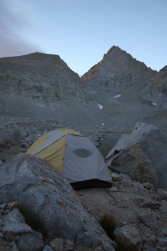
We overslept at our high mountain lake, but we were still up before sunrise. We took a photo of our tent on its perch overlooking the lake before heading out.
The sun started shining on the tops of the mountains as we started hiking.
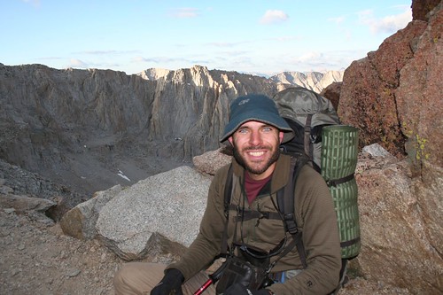
Forester Pass would be our highest point yet at 13,100’. In fact, Forester Pass would be the highest point that we’d ever hiked to. Even if you count our short hike from the top of the chairlift to the top of Peak 8 at Breckenridge, this would still be our highest hike, since Peak 8 is just under 13,000’. We’d done most of the work the previous evening to get up to Lake 12,250’, so the remainder was a piece of cake.
The view looking back down the valley was fantastic. We could see the Kearsarge Pinnacles in the foreground, with a couple of other mountain ranges behind.
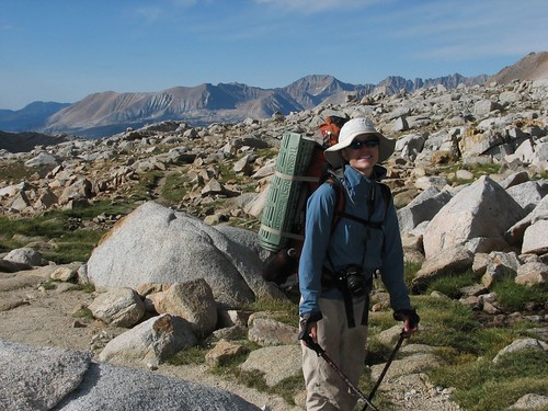
Here comes Sarah, steadily climbing the switchbacks.
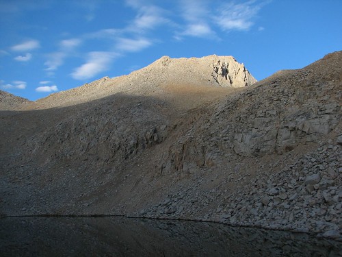
The sun finally made it up over the mountains to shine down on us and on Lake 12,250.
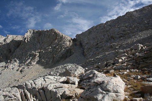
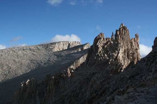
The pass wasn’t especially distinctive – just a little saddle. It’s no surprise that finding the pass is extremely difficult for hardy skiers in the winter.
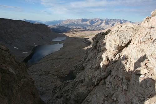
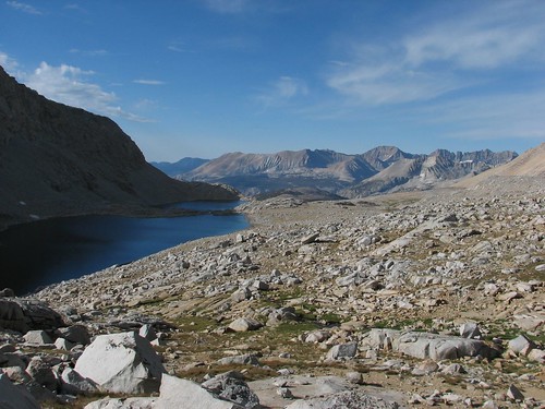
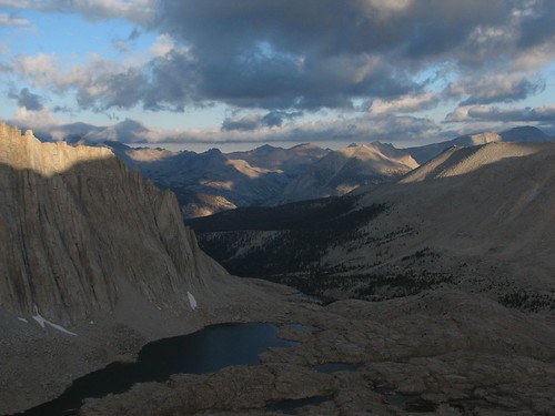
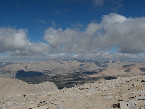
A short climb later, we were there. The view looking back was impressive, with Lake 12,250 in the foreground, Center Peak behind, and University Peak, the Center Basin Crags, and Mt. Bradley behind that.
Looking forward, we realized that even though the pass was an indistinctive saddle from the north, it was a narrow notch from the south. The views south were fantastic, but blocked by the high ridge that we were on.
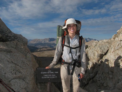
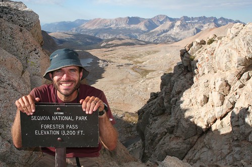
In addition to being the highest point on our hike so far, Forester Pass also marked the entrance to Sequoia National Park, our third national park of the hike.
We were the only ones at the pass, so we hung out for a little while snacking before heading down a steep switchbacking route. Looking back at the pass from the south, we were amazed that there was even a trail – the area below the pass just looked like impossibly steep and crumbly rock.
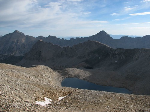
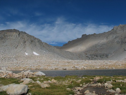
As we continued to descend, views opened up of unnamed lakes and the Kaweah peaks in the distance. Diamond Mesa towers over the two lakes at the far left.
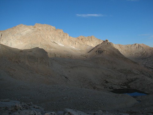
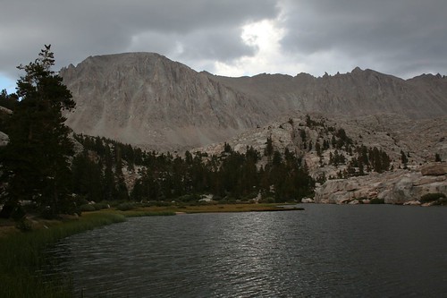
Here’s another pretty lake in the basin just below Forester Pass.
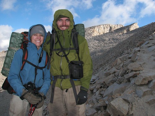
It was cool as we descended from the pass, so Sarah was still wearing her jacket.
We looked back at the pass again and noticed three people on top.
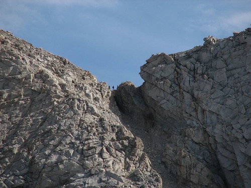
When we zoomed way in, we realized that two of the three were Doug and Mike. They’d started the day a ways back from us but had made up ground with their typical early start and fast hiking.
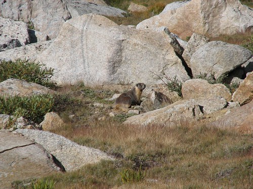
Marmots were the biggest animal that we encountered in the alpine areas on the JMT. They were a little more skittish than the marmots that we’ve encountered in Mt. Rainier National Park, but this one sat still long enough for a photo.
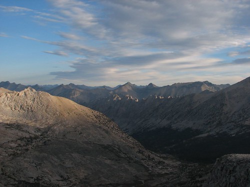
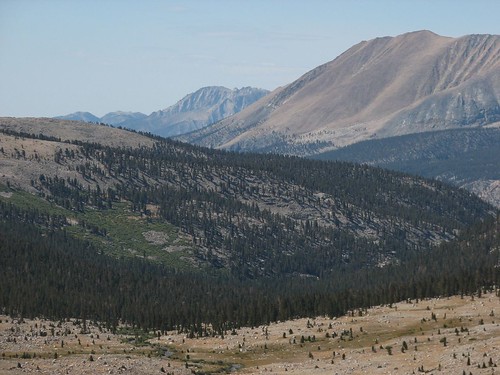
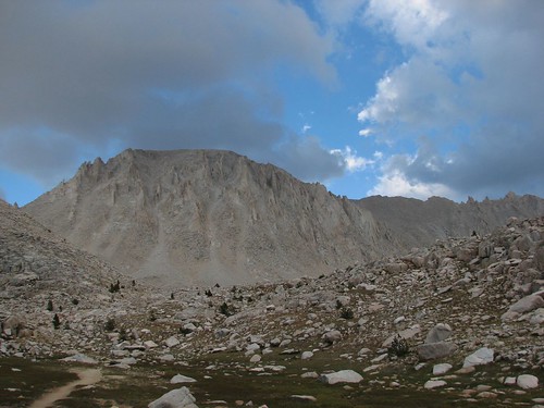
We continued hiking down from the pass, taking occasional photos of the distant mountains along the way.
Eventually, we found a creek that would make a good water source for filtering and making our oatmeal breakfast. All in all, we liked the strategy that we’d followed the past few days: We’d camp a little ways below a pass, and in the morning quickly eat Clif Bars so we could ascend to the pass as early as possible. Then we’d snack at the pass, and at the first good water source on the other side of the pass, we’d make breakfast. This way, we were on the trail before the sun rose over the mountains, resulting in nice cool shade during most of the pass climbs as well as great views as the sun rose over the mountains. The only drawback was that it sometimes took a while before we found water on the far side of the pass.
Anyway, we enjoyed our oatmeal, and as we did, Doug and Mike passed by. Shortly after that, Trevor passed us – he was a lone hiker from the U.K. who was on a several-week trip to North America. He’d heard that the JMT was the most scenic hike in the entire world, so he was starting his trip with the JMT before heading to Alaska and the Canadian Rockies. What an amazing holiday!
As soon as we started hiking again after breakfast, we heard a loud rumble. At first, we thought it was thunder, but then it kept going – way too long to be thunder. Besides, there were just a few puffy clouds in the sky – it certainly didn’t look like a thunderstorm was imminent. After a few seconds, we realized it was a rockslide, quite nearby! We could actually see the rocks sliding, and the dust cloud that they created.

Then, just a little ways further, we reached our first sign for Mt. Whitney since Yosemite. In Yosemite, Whitney had been 211 miles away, but now we only had 16.1 miles to go!

Next we hiked down into some trees and met up with Trevor, Doug and Mike, and their friend Jeff by a creek crossing. Doug warned us that this was the last good water source for a few miles, so we decided to join them and filter some more water. They had a SteriPEN – one of their cool backcountry gadgets – so they just had to push a button to zap their water with UV light, while we invested sweat equity to pump our water through a carbon filter.
While Brian filtered, Sarah chatted with them. Given that we live in Seattle and seemed educated, they said, they guessed we worked at Microsoft. We confirmed their guess. Sarah asked how they stay in shape, and Doug said he surfs, hikes a lot, and takes care of a four-acre property – pretty impressive for a guy who’s nearly our parents’ age.
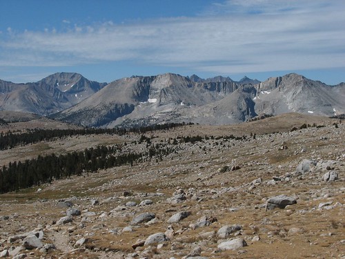
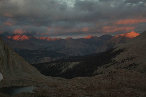
Next we hiked up to Bighorn Plateau as the thunderclouds mounted. The sunlight filtering through the clouds made for stunning patterns of light and shadow on the mountains.

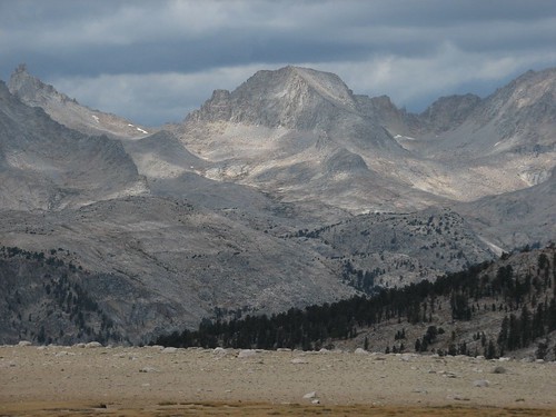
We also got some good views of Mt. Whitney, the flat-topped mountain on the right in this photo:
We’d been talking with Doug and Mike about our options for ascending Mt. Whitney. The most common way to do it is to hike to Guitar Lake the night before your ascent, leaving a relatively short hike the next morning to the top. Another option is to camp right at Trail Junction, well above treeline – it’s a more exposed and less comfortable place to camp, but it leaves just 1.9 miles to the summit. Afternoon thunderstorms are a potentially lethal threat at the top of Mt. Whitney, so it’s highly recommended to summit the mountain early and be down by early afternoon. A third option is to camp right at the top of Whitney – potentially extremely dangerous on a stormy night, but an amazing experience on a clear, calm night. The next day would be our fifth anniversary, and Doug had planted in our heads the idea that spending the night of our anniversary at the highest point in the lower 48 states would be a fantastic experience. So that was our working plan.
As was typical, Doug and Mike passed us on Bighorn Plateau, but we caught up with them when they stopped to chat with a couple who turned out to be JMT experts. They hike the JMT every year, and the man is the son of the guy who owns an outdoor gear shop in San Diego. They’d had dinner with Wayne Gregory just a week before, and he’d outfitted them with new Gregory packs to test out on their trip. Anyway, they were on the third day of a south-to-north thru-hike, so they had a relatively up-to-date weather forecast, and it didn’t sound good. The monsoonal weather – read: thunderstorms – was expected to continue for the next two days, followed by a cold front. We decided that spending the next night on top of Mt. Whitney seemed like a bad idea.
Instead, we reverted to the default option – camping at Guitar Lake and then summiting Whitney the following morning. We were still enamored with the idea of hiking to the top of the highest point in the lower 48 on our anniversary, so we decided to push on to Guitar Lake today. All factors were on our side – the trail was pretty smooth, the grade was small, the air was cool due to the cloud cover, and thunderstorms never materialized. We blazed through without taking many pictures.
We reached the Crabtree Meadow junction, where we had to pick up “wag bags”. A wag bag is a plastic bag for solid human waste. Seriously. Apparently, the Mt. Whitney area gets so much traffic that the typical way to go to the bathroom in the backcountry – digging a six-inch hole and packing out your toilet paper – isn’t good enough to keep pollution at an acceptable level, so hikers have to go in a bag and carry it out. For the next day and a half that we would be in the Whitney area, Sarah would manage to avoid using hers. Brian did use his, and thankfully managed to avoid any disastrous leaks.
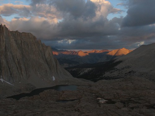
We followed Whitney Creek up from Crabtree Meadow and got more nice views of Mt. Whitney under the dark skies.
Next we came to Timberline Lake, famous for its reflection views of Whitney. With the stormy, breezy skies, there was no reflection, but it was still a pretty setting.
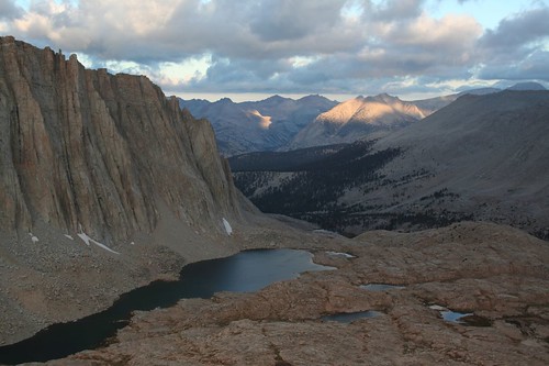
As we hiked up from Timberline Lake, the skies started to clear up.
As the skies continued to clear and the sun got lower in the sky, the patterns of light and shadow on Whitney were beautiful.

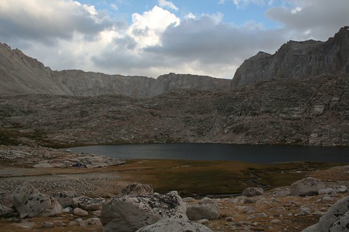
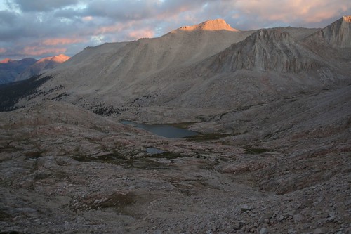
Just a few minutes later, we made it to Guitar Lake. The area where the trail hit the lake was crowded with campers, but we hiked around to the guitar’s “neck” and found a gorgeous site that was nicely sheltered from the wind. Here’s the view across the lake from our site:
The upcoming stretch was the longest waterless stretch on the trail – from Guitar Lake to the top of Mt. Whitney to Trail Camp, the next water on the other side of Mt. Whitney, was about 10 miles. So as the sun set, Sarah filtered over a gallon of water while Brian made dinner and took more pictures.
The sunset light on the rocks across the lake was a pretty orange color, and our tent had unobstructed views.

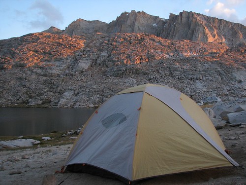
As the sun set further, the light only got better.
We ate dinner, drank a lot of water, and filtered two more liters so we’d be all set to leave bright and early in the morning. Fortunately, the wind died down right around sunset, and we got a very good night’s sleep. We’d hiked 17.6 miles this day, our longest day yet, for a total of 203.4.
Before 5 AM, we were up and moving around, and at 5:30, we were on the trail, hiking by headlamp light. By the time there was enough light to put our headlamps away, we’d made significant progress toward the summit, and the views of pinkish clouds above the Kahweahs were beautiful.
A few minutes later, the sunlight had reached the tops of the Kahweahs.
It was chilly but calm, and very comfortable for hiking. As we switchbacked up toward Trail Junction, where we would turn off for Mt. Whitney, we kept looking back at the changing sunrise light on the mountains behind us.

Then, suddenly, the orange sunrise light gave way to white daytime light. Even though the colors weren’t as pretty, the pattern of light and shadow cast by the clouds made for more good photos.
Then the wind picked up, and chilly but comfortable weather turned brutally cold. We reached Trail Junction, where many people leave their packs, but we just kept hiking. At Trail Junction, we turned left – having climbed to a high ridge, we would now follow the ridge most of the remaining way to the summit.
Battered by the wind, we took advantage of the occasional windbreaks, which were few and far between. Here’s Brian, huddled at the base of a protective rock wall.
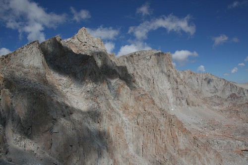
After hiking along the ridge a ways, we got our first view of the hut at the summit. In front of the summit are two pinnacles.
We met another couple who had hiked the High Sierra Trail and were also finishing their hike at the summit of Mt. Whitney. We took each other’s pictures at another windbreak.
Here’s Sarah, squinting against the wind:
As we hurried up the mountain, thinking only of getting relief from the wind, we took few pictures. The views were impressive, though – in the moments that we took to look around, we increasingly felt like we were on top of the world.

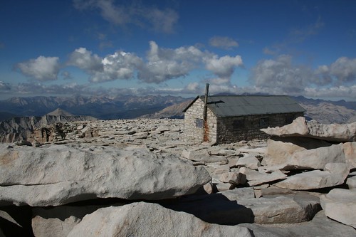
And then, after a final swift climb, we reached the summit house. Without looking around, we opened the door, jumped inside, and hefted the door shut, fighting the wind. The hut turned out to be a very tiny room that was packed with people – although we’d arrived early in the morning, we definitely weren’t the first ones there. We were starving after a steep climb with few breaks, and we spent the next minutes stuffing ourselves with granola, trail mix, M&Ms, and water. Eventually, we realized that we were still cold, so we stripped down to our underwear so we could throw on long underwear under our clothes. If the other people in the hut minded, they didn’t comment.
We spent close to an hour in the hut, enjoying our respite from the wind and refueling for the hike down. While we were there, we chatted with other people who were doing the same. We met a guy who had started hiking at 9 PM the night before from the trailhead in Whitney Portal and finished the 11-mile hike at 9 AM. He said the wind had been horrendous all night long. Another guy in the hut was from South America someplace – Chile, we think – and despite some altitude sickness on the way up, had made it. A woman had summited Mt. Whitney three times and said this was the worst weather she’d faced.
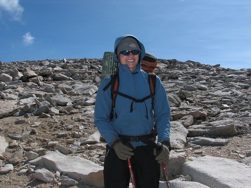
Eventually, we decided that we should check out the actual summit, only 50 feet or so from the hut through the atrocious wind. Here’s Brian, standing at the top of the continental U.S.:

Here’s the view looking back at the hut:
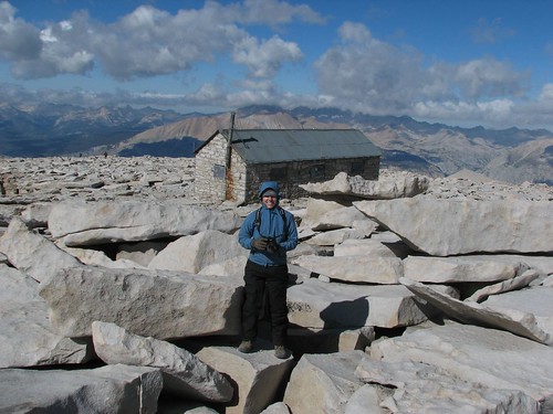
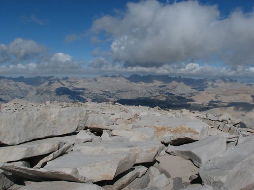
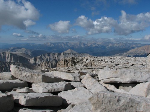
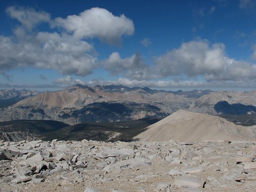
The views all around were fantastic:
A sign commemorated the end of the JMT:
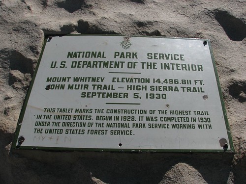
We’d made it! We’d hiked over 200 miles from Yosemite Valley to the top of Mt. Whitney and the official end of the John Muir Trail! Now we just had to hike 11 miles to the trailhead at Whitney Portal.
After collecting our packs from the summit house, we started down, bracing ourselves against the stiff wind. Here’s Sarah, bundled up for the descent:
We got more amazing views as we headed down:
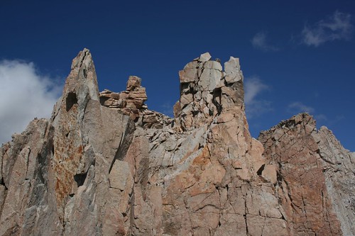
The Pinnacles loomed ahead:

Although the wind was insane, there was one good thing: The wind was blowing from the west, and the trail traversed just below the ridge on the west side. In other words, if the wind blew us over – which was a very real possibility – it would blow us into the mountain, and the mountain would catch us. The exception was when we passed the notches between the Pinnacles. There, we were hiking on a five-foot-wide ledge in what was essentially a wind tunnel trying to blow us through the notch and off the mountain to the east. Everywhere else, the hike to the summit was unpleasant, but in those spots it was life-threatening. We made it through without incident, although we wished we’d left our packs, which caught the wind, at the junction.
We continued to hike quickly, taking few breaks. We did take a photo looking back down at Guitar Lake on the right side of this photo. It really does look like a guitar from above.

As we were heading down, we saw Doug, Mike, Jeff, and Trevor again. After hurried hellos and goodbyes, we passed Trail junction and began the short climb toward Trail Crest, the last and highest of the 11 major passes on the JMT. If anything, the notch below Trail Crest was the worst of all, with stiff winds similar to or worse than those at the notches between the Pinnacles. Having safely passed through, we found a large crowd of people at Trail Crest, many of whom had made it that far – nine miles and 5000 feet of elevation gain – only to have to decide whether it was safe to proceed. We told them about our experience, and several people decided to turn around, which was probably a wise decision. We would find out later from a ranger that someone had measured the wind at up to 80 MPH!
Seeing all the day hikers heading up Mt. Whitney was an experience unto itself. Many of them looked like they were ill-equipped for a walk in a neighborhood park, never mind an extremely long and challenging day hike (21 miles and 6,000 feet of elevation gain and loss) at high elevation. Several groups walked by in shorts and cotton sweatshirts, carrying nothing but a bottle of water. There were some groups still heading up to Trail Crest after noon. Another couple looked like they were ready to have heart failure and weren’t even halfway up to Trail Crest. Many of these people also seemed to have no concept of how far they had to go at that point. A ranger we spoke to later said that they have a lot of problems with day hikers getting tunnel vision – they do all this planning (i.e. apply for a permit), go to the gym once or twice, and think they’re ready to summit. Despite all sorts of inclement weather, including active thunderstorms, they continue to push on.
Heading east from the pass, we had some nice views of rock formations.
But the wind just didn’t let up, so we made a beeline for treeline (well, as much of a beeline as possible given the 100 switchbacks between us and Trail Camp and more after that). We considered camping at Trail Camp, which was quite scenic, but it offered no protection from the stiff winds, so we pressed onward. We passed more people on their way up as we were heading down, mostly backpackers planning to camp at Trail Camp and summit tomorrow. One particularly noteworthy group included a guy in jeans and work boots carrying a Coleman tent still in its package. Ugh!
Finally, we made it to Outpost Camp, just below treeline, and Sarah found a nice camping spot near a gorgeous waterfall. The site was positioned right in the corner of the campground near a steep rock wall that afforded good wind protection. We sat for a long time in our gloriously sheltered campsite, overjoyed to not be battered by the wind.
Sarah’s boots, which were not in good shape when we started the hike, had definitely outlived their useful life.
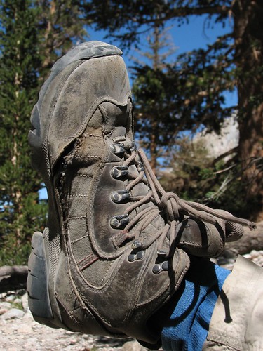
She’d had these boots for years and considered throwing them away before we started the hike, but ultimately decided to wear them for 220 more miles because they were her most comfortable option. It was a good choice – she didn’t have any foot problems on the hike, and we had great weather, so she didn’t have any issues with water flooding her boots through the gaping holes at the seams.
After basking in our relatively wind-free campsite, we set up our tent for the last time on the JMT.
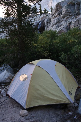
It was a little sad to think that this was our last night – we’d had a wonderful time.
Later in the afternoon, Doug, Mike, Trevor, and Jeff appeared and staked out a campsite. Doug and Mike were pretty much out of food, so we gave them some trail mix, which they gratefully started devouring. Even so, after chatting with us for a while, they decided to hike the rest of the way down to the trailhead so they could get beer, pizza, and showers in Lone Pine. They invited us to join them, but we had already set up camp, and besides, we couldn’t pick up Caroline at the body shop until Tuesday – today was Sunday, and tomorrow was Labor Day. We had enough food, too, so we weren’t in any hurry to get off the trail. We declined and said our final goodbyes to our trail buddies.
The next morning, we got up bright and early, as usual, and started hiking down. We skipped our oatmeal breakfast because Doug had told us about 24-inch pancakes at the café at Whitney Portal, the trailhead. 24 inches had to be an exaggeration, but after 16 days of oatmeal, pancakes sounded pretty good.
We took a last picture of the pretty Sierra granite in the early morning light, which we knew we’d miss:
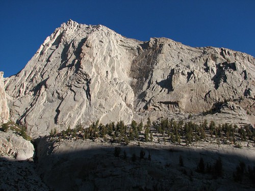
As we departed the wilderness, a passing hiker took our picture.
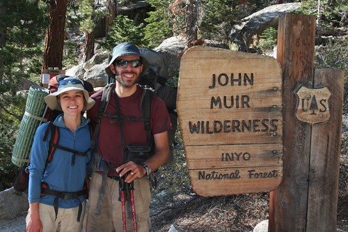
A mile later, we were at Whitney Portal. At the trailhead, we met a group of six or seven women who were beginning a two-night backpacking trip to climb Mt. Whitney. When they found out that we had hiked the JMT, they asked Brian who he was. He told them, and they asked, “Is your wife named Sarah?” When Brian said yes, they wished us a happy anniversary! We’d never seen these women before in our lives! It turned out that they had been at the Lone Pine pizza place around 9 PM the night before when Doug and Mike and the gang arrived, and had struck up a conversation.
Then the women asked Brian to take off his sunglasses, and they all oohed and ahhed – apparently, Doug had told them that they’d recognize Brian by his blue eyes, and that they should wish us a happy anniversary. How cool!
At the Whitney Portal café, there were three choices for breakfast: a single pancake, the same single pancake with eggs and bacon, and another combo that didn’t include a pancake. Having heard about the legendary pancakes but thinking that eggs and bacon sounded fantastic, too – basically, anything not cooked in a pot sounded wonderful – we ordered the pancake combo.
The JMT is full of wonderful magic. Just as the impossible-sounding legend of cold beer at Silver Pass had turned out to be true, so did the legend of the 24-inch pancake.
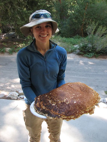
The cook served up the pancake on two plates, but even two plates weren’t enough to contain the pancake, which overflowed onto the picnic table where we ate. Keeping our syrup from flowing downhill, off the pancake and onto the table, was a special challenge. We sat with four other hikers whom we’d met the previous day, and everyone was in awe. It was bigger than a pizza. Thicker, too – it was 1.5 inches or so thick at the center. And after hiking for 17 days, it tasted amazing. A hot topic of discussion was how the heck the cook flipped such a huge pancake – we decided that he must have had one of those huge spatulas for flipping pizza crust.
Oh, but the pancake wasn’t at all. We’d ordered the combo, so on a third plate, the cook served up about seven strips of bacon and four scrambled eggs. It was an insanely glorious amount of scrumptious non-freeze-dried splendor.
After eating all the bacon, all the eggs, and at least half of the pancake, we were blissful and nearly comatose. We’d weighed ourselves on the scale in the Whitney Portal store, and decided that we’d eaten pretty well on our hike – Sarah had lost about five pounds, and Brian had maintained his weight. That was before breakfast, though – by the end of breakfast, we were each probably a few pounds heaver.
One of the couples who ate breakfast with us gave us a ride from Whitney Portal out to Lone Pine, and in Lone Pine, we bought some orange juice and newspapers. We found out that the baseball pennant races hadn’t changed much, and that Joe Biden and Sarah Palin had been chosen as the presidential running mates. Then Brian acquired a Sierra Nevada beer to commemorate the completion of our journey through the Sierras, and we settled in at the bus stop to wait for the bus that would take us to Bishop, where we’d pick up Caroline from the body shop the next morning, hopefully all patched up after being terrorized by the bear.
What a trip it had been! In all of our backpacking, this was the most amazing trip we’ve done. We were initially skeptical about a trip that was so long, but we’d do it again in a heartbeat. In the words of John Muir, “Everybody needs beauty as well as bread, places to play in and pray in where nature may heal and cheer and give strength to the body and soul.” For us, the John Muir Trail certainly fit the bill.
The sun started shining on the tops of the mountains as we started hiking.
Forester Pass would be our highest point yet at 13,100’. In fact, Forester Pass would be the highest point that we’d ever hiked to. Even if you count our short hike from the top of the chairlift to the top of Peak 8 at Breckenridge, this would still be our highest hike, since Peak 8 is just under 13,000’. We’d done most of the work the previous evening to get up to Lake 12,250’, so the remainder was a piece of cake.
The view looking back down the valley was fantastic. We could see the Kearsarge Pinnacles in the foreground, with a couple of other mountain ranges behind.
Here comes Sarah, steadily climbing the switchbacks.
The sun finally made it up over the mountains to shine down on us and on Lake 12,250.
The pass wasn’t especially distinctive – just a little saddle. It’s no surprise that finding the pass is extremely difficult for hardy skiers in the winter.
A short climb later, we were there. The view looking back was impressive, with Lake 12,250 in the foreground, Center Peak behind, and University Peak, the Center Basin Crags, and Mt. Bradley behind that.
Looking forward, we realized that even though the pass was an indistinctive saddle from the north, it was a narrow notch from the south. The views south were fantastic, but blocked by the high ridge that we were on.
In addition to being the highest point on our hike so far, Forester Pass also marked the entrance to Sequoia National Park, our third national park of the hike.
We were the only ones at the pass, so we hung out for a little while snacking before heading down a steep switchbacking route. Looking back at the pass from the south, we were amazed that there was even a trail – the area below the pass just looked like impossibly steep and crumbly rock.
As we continued to descend, views opened up of unnamed lakes and the Kaweah peaks in the distance. Diamond Mesa towers over the two lakes at the far left.
Here’s another pretty lake in the basin just below Forester Pass.
It was cool as we descended from the pass, so Sarah was still wearing her jacket.
We looked back at the pass again and noticed three people on top.
When we zoomed way in, we realized that two of the three were Doug and Mike. They’d started the day a ways back from us but had made up ground with their typical early start and fast hiking.
Marmots were the biggest animal that we encountered in the alpine areas on the JMT. They were a little more skittish than the marmots that we’ve encountered in Mt. Rainier National Park, but this one sat still long enough for a photo.
We continued hiking down from the pass, taking occasional photos of the distant mountains along the way.
Eventually, we found a creek that would make a good water source for filtering and making our oatmeal breakfast. All in all, we liked the strategy that we’d followed the past few days: We’d camp a little ways below a pass, and in the morning quickly eat Clif Bars so we could ascend to the pass as early as possible. Then we’d snack at the pass, and at the first good water source on the other side of the pass, we’d make breakfast. This way, we were on the trail before the sun rose over the mountains, resulting in nice cool shade during most of the pass climbs as well as great views as the sun rose over the mountains. The only drawback was that it sometimes took a while before we found water on the far side of the pass.
Anyway, we enjoyed our oatmeal, and as we did, Doug and Mike passed by. Shortly after that, Trevor passed us – he was a lone hiker from the U.K. who was on a several-week trip to North America. He’d heard that the JMT was the most scenic hike in the entire world, so he was starting his trip with the JMT before heading to Alaska and the Canadian Rockies. What an amazing holiday!
As soon as we started hiking again after breakfast, we heard a loud rumble. At first, we thought it was thunder, but then it kept going – way too long to be thunder. Besides, there were just a few puffy clouds in the sky – it certainly didn’t look like a thunderstorm was imminent. After a few seconds, we realized it was a rockslide, quite nearby! We could actually see the rocks sliding, and the dust cloud that they created.
Then, just a little ways further, we reached our first sign for Mt. Whitney since Yosemite. In Yosemite, Whitney had been 211 miles away, but now we only had 16.1 miles to go!
Next we hiked down into some trees and met up with Trevor, Doug and Mike, and their friend Jeff by a creek crossing. Doug warned us that this was the last good water source for a few miles, so we decided to join them and filter some more water. They had a SteriPEN – one of their cool backcountry gadgets – so they just had to push a button to zap their water with UV light, while we invested sweat equity to pump our water through a carbon filter.
While Brian filtered, Sarah chatted with them. Given that we live in Seattle and seemed educated, they said, they guessed we worked at Microsoft. We confirmed their guess. Sarah asked how they stay in shape, and Doug said he surfs, hikes a lot, and takes care of a four-acre property – pretty impressive for a guy who’s nearly our parents’ age.
Next we hiked up to Bighorn Plateau as the thunderclouds mounted. The sunlight filtering through the clouds made for stunning patterns of light and shadow on the mountains.
We also got some good views of Mt. Whitney, the flat-topped mountain on the right in this photo:
We’d been talking with Doug and Mike about our options for ascending Mt. Whitney. The most common way to do it is to hike to Guitar Lake the night before your ascent, leaving a relatively short hike the next morning to the top. Another option is to camp right at Trail Junction, well above treeline – it’s a more exposed and less comfortable place to camp, but it leaves just 1.9 miles to the summit. Afternoon thunderstorms are a potentially lethal threat at the top of Mt. Whitney, so it’s highly recommended to summit the mountain early and be down by early afternoon. A third option is to camp right at the top of Whitney – potentially extremely dangerous on a stormy night, but an amazing experience on a clear, calm night. The next day would be our fifth anniversary, and Doug had planted in our heads the idea that spending the night of our anniversary at the highest point in the lower 48 states would be a fantastic experience. So that was our working plan.
As was typical, Doug and Mike passed us on Bighorn Plateau, but we caught up with them when they stopped to chat with a couple who turned out to be JMT experts. They hike the JMT every year, and the man is the son of the guy who owns an outdoor gear shop in San Diego. They’d had dinner with Wayne Gregory just a week before, and he’d outfitted them with new Gregory packs to test out on their trip. Anyway, they were on the third day of a south-to-north thru-hike, so they had a relatively up-to-date weather forecast, and it didn’t sound good. The monsoonal weather – read: thunderstorms – was expected to continue for the next two days, followed by a cold front. We decided that spending the next night on top of Mt. Whitney seemed like a bad idea.
Instead, we reverted to the default option – camping at Guitar Lake and then summiting Whitney the following morning. We were still enamored with the idea of hiking to the top of the highest point in the lower 48 on our anniversary, so we decided to push on to Guitar Lake today. All factors were on our side – the trail was pretty smooth, the grade was small, the air was cool due to the cloud cover, and thunderstorms never materialized. We blazed through without taking many pictures.
We reached the Crabtree Meadow junction, where we had to pick up “wag bags”. A wag bag is a plastic bag for solid human waste. Seriously. Apparently, the Mt. Whitney area gets so much traffic that the typical way to go to the bathroom in the backcountry – digging a six-inch hole and packing out your toilet paper – isn’t good enough to keep pollution at an acceptable level, so hikers have to go in a bag and carry it out. For the next day and a half that we would be in the Whitney area, Sarah would manage to avoid using hers. Brian did use his, and thankfully managed to avoid any disastrous leaks.
We followed Whitney Creek up from Crabtree Meadow and got more nice views of Mt. Whitney under the dark skies.
Next we came to Timberline Lake, famous for its reflection views of Whitney. With the stormy, breezy skies, there was no reflection, but it was still a pretty setting.
As we hiked up from Timberline Lake, the skies started to clear up.
As the skies continued to clear and the sun got lower in the sky, the patterns of light and shadow on Whitney were beautiful.
Just a few minutes later, we made it to Guitar Lake. The area where the trail hit the lake was crowded with campers, but we hiked around to the guitar’s “neck” and found a gorgeous site that was nicely sheltered from the wind. Here’s the view across the lake from our site:
The upcoming stretch was the longest waterless stretch on the trail – from Guitar Lake to the top of Mt. Whitney to Trail Camp, the next water on the other side of Mt. Whitney, was about 10 miles. So as the sun set, Sarah filtered over a gallon of water while Brian made dinner and took more pictures.
The sunset light on the rocks across the lake was a pretty orange color, and our tent had unobstructed views.
As the sun set further, the light only got better.
We ate dinner, drank a lot of water, and filtered two more liters so we’d be all set to leave bright and early in the morning. Fortunately, the wind died down right around sunset, and we got a very good night’s sleep. We’d hiked 17.6 miles this day, our longest day yet, for a total of 203.4.
Before 5 AM, we were up and moving around, and at 5:30, we were on the trail, hiking by headlamp light. By the time there was enough light to put our headlamps away, we’d made significant progress toward the summit, and the views of pinkish clouds above the Kahweahs were beautiful.
A few minutes later, the sunlight had reached the tops of the Kahweahs.
It was chilly but calm, and very comfortable for hiking. As we switchbacked up toward Trail Junction, where we would turn off for Mt. Whitney, we kept looking back at the changing sunrise light on the mountains behind us.
Then, suddenly, the orange sunrise light gave way to white daytime light. Even though the colors weren’t as pretty, the pattern of light and shadow cast by the clouds made for more good photos.
Then the wind picked up, and chilly but comfortable weather turned brutally cold. We reached Trail Junction, where many people leave their packs, but we just kept hiking. At Trail Junction, we turned left – having climbed to a high ridge, we would now follow the ridge most of the remaining way to the summit.
Battered by the wind, we took advantage of the occasional windbreaks, which were few and far between. Here’s Brian, huddled at the base of a protective rock wall.
After hiking along the ridge a ways, we got our first view of the hut at the summit. In front of the summit are two pinnacles.
We met another couple who had hiked the High Sierra Trail and were also finishing their hike at the summit of Mt. Whitney. We took each other’s pictures at another windbreak.
Here’s Sarah, squinting against the wind:
As we hurried up the mountain, thinking only of getting relief from the wind, we took few pictures. The views were impressive, though – in the moments that we took to look around, we increasingly felt like we were on top of the world.
And then, after a final swift climb, we reached the summit house. Without looking around, we opened the door, jumped inside, and hefted the door shut, fighting the wind. The hut turned out to be a very tiny room that was packed with people – although we’d arrived early in the morning, we definitely weren’t the first ones there. We were starving after a steep climb with few breaks, and we spent the next minutes stuffing ourselves with granola, trail mix, M&Ms, and water. Eventually, we realized that we were still cold, so we stripped down to our underwear so we could throw on long underwear under our clothes. If the other people in the hut minded, they didn’t comment.
We spent close to an hour in the hut, enjoying our respite from the wind and refueling for the hike down. While we were there, we chatted with other people who were doing the same. We met a guy who had started hiking at 9 PM the night before from the trailhead in Whitney Portal and finished the 11-mile hike at 9 AM. He said the wind had been horrendous all night long. Another guy in the hut was from South America someplace – Chile, we think – and despite some altitude sickness on the way up, had made it. A woman had summited Mt. Whitney three times and said this was the worst weather she’d faced.
Eventually, we decided that we should check out the actual summit, only 50 feet or so from the hut through the atrocious wind. Here’s Brian, standing at the top of the continental U.S.:
Here’s the view looking back at the hut:
The views all around were fantastic:
A sign commemorated the end of the JMT:
We’d made it! We’d hiked over 200 miles from Yosemite Valley to the top of Mt. Whitney and the official end of the John Muir Trail! Now we just had to hike 11 miles to the trailhead at Whitney Portal.
After collecting our packs from the summit house, we started down, bracing ourselves against the stiff wind. Here’s Sarah, bundled up for the descent:
We got more amazing views as we headed down:
The Pinnacles loomed ahead:
Although the wind was insane, there was one good thing: The wind was blowing from the west, and the trail traversed just below the ridge on the west side. In other words, if the wind blew us over – which was a very real possibility – it would blow us into the mountain, and the mountain would catch us. The exception was when we passed the notches between the Pinnacles. There, we were hiking on a five-foot-wide ledge in what was essentially a wind tunnel trying to blow us through the notch and off the mountain to the east. Everywhere else, the hike to the summit was unpleasant, but in those spots it was life-threatening. We made it through without incident, although we wished we’d left our packs, which caught the wind, at the junction.
We continued to hike quickly, taking few breaks. We did take a photo looking back down at Guitar Lake on the right side of this photo. It really does look like a guitar from above.
As we were heading down, we saw Doug, Mike, Jeff, and Trevor again. After hurried hellos and goodbyes, we passed Trail junction and began the short climb toward Trail Crest, the last and highest of the 11 major passes on the JMT. If anything, the notch below Trail Crest was the worst of all, with stiff winds similar to or worse than those at the notches between the Pinnacles. Having safely passed through, we found a large crowd of people at Trail Crest, many of whom had made it that far – nine miles and 5000 feet of elevation gain – only to have to decide whether it was safe to proceed. We told them about our experience, and several people decided to turn around, which was probably a wise decision. We would find out later from a ranger that someone had measured the wind at up to 80 MPH!
Seeing all the day hikers heading up Mt. Whitney was an experience unto itself. Many of them looked like they were ill-equipped for a walk in a neighborhood park, never mind an extremely long and challenging day hike (21 miles and 6,000 feet of elevation gain and loss) at high elevation. Several groups walked by in shorts and cotton sweatshirts, carrying nothing but a bottle of water. There were some groups still heading up to Trail Crest after noon. Another couple looked like they were ready to have heart failure and weren’t even halfway up to Trail Crest. Many of these people also seemed to have no concept of how far they had to go at that point. A ranger we spoke to later said that they have a lot of problems with day hikers getting tunnel vision – they do all this planning (i.e. apply for a permit), go to the gym once or twice, and think they’re ready to summit. Despite all sorts of inclement weather, including active thunderstorms, they continue to push on.
Heading east from the pass, we had some nice views of rock formations.
But the wind just didn’t let up, so we made a beeline for treeline (well, as much of a beeline as possible given the 100 switchbacks between us and Trail Camp and more after that). We considered camping at Trail Camp, which was quite scenic, but it offered no protection from the stiff winds, so we pressed onward. We passed more people on their way up as we were heading down, mostly backpackers planning to camp at Trail Camp and summit tomorrow. One particularly noteworthy group included a guy in jeans and work boots carrying a Coleman tent still in its package. Ugh!
Finally, we made it to Outpost Camp, just below treeline, and Sarah found a nice camping spot near a gorgeous waterfall. The site was positioned right in the corner of the campground near a steep rock wall that afforded good wind protection. We sat for a long time in our gloriously sheltered campsite, overjoyed to not be battered by the wind.
Sarah’s boots, which were not in good shape when we started the hike, had definitely outlived their useful life.
She’d had these boots for years and considered throwing them away before we started the hike, but ultimately decided to wear them for 220 more miles because they were her most comfortable option. It was a good choice – she didn’t have any foot problems on the hike, and we had great weather, so she didn’t have any issues with water flooding her boots through the gaping holes at the seams.
After basking in our relatively wind-free campsite, we set up our tent for the last time on the JMT.
It was a little sad to think that this was our last night – we’d had a wonderful time.
Later in the afternoon, Doug, Mike, Trevor, and Jeff appeared and staked out a campsite. Doug and Mike were pretty much out of food, so we gave them some trail mix, which they gratefully started devouring. Even so, after chatting with us for a while, they decided to hike the rest of the way down to the trailhead so they could get beer, pizza, and showers in Lone Pine. They invited us to join them, but we had already set up camp, and besides, we couldn’t pick up Caroline at the body shop until Tuesday – today was Sunday, and tomorrow was Labor Day. We had enough food, too, so we weren’t in any hurry to get off the trail. We declined and said our final goodbyes to our trail buddies.
The next morning, we got up bright and early, as usual, and started hiking down. We skipped our oatmeal breakfast because Doug had told us about 24-inch pancakes at the café at Whitney Portal, the trailhead. 24 inches had to be an exaggeration, but after 16 days of oatmeal, pancakes sounded pretty good.
We took a last picture of the pretty Sierra granite in the early morning light, which we knew we’d miss:
As we departed the wilderness, a passing hiker took our picture.
A mile later, we were at Whitney Portal. At the trailhead, we met a group of six or seven women who were beginning a two-night backpacking trip to climb Mt. Whitney. When they found out that we had hiked the JMT, they asked Brian who he was. He told them, and they asked, “Is your wife named Sarah?” When Brian said yes, they wished us a happy anniversary! We’d never seen these women before in our lives! It turned out that they had been at the Lone Pine pizza place around 9 PM the night before when Doug and Mike and the gang arrived, and had struck up a conversation.
Then the women asked Brian to take off his sunglasses, and they all oohed and ahhed – apparently, Doug had told them that they’d recognize Brian by his blue eyes, and that they should wish us a happy anniversary. How cool!
At the Whitney Portal café, there were three choices for breakfast: a single pancake, the same single pancake with eggs and bacon, and another combo that didn’t include a pancake. Having heard about the legendary pancakes but thinking that eggs and bacon sounded fantastic, too – basically, anything not cooked in a pot sounded wonderful – we ordered the pancake combo.
The JMT is full of wonderful magic. Just as the impossible-sounding legend of cold beer at Silver Pass had turned out to be true, so did the legend of the 24-inch pancake.
The cook served up the pancake on two plates, but even two plates weren’t enough to contain the pancake, which overflowed onto the picnic table where we ate. Keeping our syrup from flowing downhill, off the pancake and onto the table, was a special challenge. We sat with four other hikers whom we’d met the previous day, and everyone was in awe. It was bigger than a pizza. Thicker, too – it was 1.5 inches or so thick at the center. And after hiking for 17 days, it tasted amazing. A hot topic of discussion was how the heck the cook flipped such a huge pancake – we decided that he must have had one of those huge spatulas for flipping pizza crust.
Oh, but the pancake wasn’t at all. We’d ordered the combo, so on a third plate, the cook served up about seven strips of bacon and four scrambled eggs. It was an insanely glorious amount of scrumptious non-freeze-dried splendor.
After eating all the bacon, all the eggs, and at least half of the pancake, we were blissful and nearly comatose. We’d weighed ourselves on the scale in the Whitney Portal store, and decided that we’d eaten pretty well on our hike – Sarah had lost about five pounds, and Brian had maintained his weight. That was before breakfast, though – by the end of breakfast, we were each probably a few pounds heaver.
One of the couples who ate breakfast with us gave us a ride from Whitney Portal out to Lone Pine, and in Lone Pine, we bought some orange juice and newspapers. We found out that the baseball pennant races hadn’t changed much, and that Joe Biden and Sarah Palin had been chosen as the presidential running mates. Then Brian acquired a Sierra Nevada beer to commemorate the completion of our journey through the Sierras, and we settled in at the bus stop to wait for the bus that would take us to Bishop, where we’d pick up Caroline from the body shop the next morning, hopefully all patched up after being terrorized by the bear.
What a trip it had been! In all of our backpacking, this was the most amazing trip we’ve done. We were initially skeptical about a trip that was so long, but we’d do it again in a heartbeat. In the words of John Muir, “Everybody needs beauty as well as bread, places to play in and pray in where nature may heal and cheer and give strength to the body and soul.” For us, the John Muir Trail certainly fit the bill.
Subscribe to:
Comments (Atom)